IMAGES TAKEN NEAR TO
Ballyregan Road, HOLYWOOD, BT18 9RP
Introduction
This page details the photographs taken nearby to Ballyregan Road, BT18 9RP by members of the Geograph project.
The Geograph project started in 2005 with the aim of publishing, organising and preserving representative images for every square kilometre of Great Britain, Ireland and the Isle of Man.

There are currently over 7.5m images from over14,400 individuals and you can help contribute to the project by visiting https://www.geograph.org.uk
Image Map
Images are licensed for reuse under creativecommons.org/licenses/by-sa/2.0
Notes
- Clicking on the map will re-center to the selected point.
- The higher the marker number, the further away the image location is from the centre of the postcode.
Image Listing (20 Images Found)
Images are licensed for reuse under creativecommons.org/licenses/by-sa/2.0
Image
Details
Distance
1
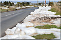
Snow, Ballykeel near Craigantlet (2013-3)
Cleared snow by the side of the Ballyregan Road, near here Image, at a height of about 550ft.
Image: © Albert Bridge
Taken: 9 Apr 2013
0.07 miles
2
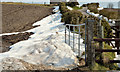
Snow, Ballykeel near Craigantlet (2013-2)
Snow, behind a hedge at a height of about 550ft, on the eastern side of the Ballyregan Road.
Image: © Albert Bridge
Taken: 9 Apr 2013
0.08 miles
3
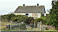
Vacant house, Ballykeel, Craigantlet (December 2018)
See Image (April 2013). Still vacant. It appears to be no 58 Ballymiscaw Road.
Image: © Albert Bridge
Taken: 29 Dec 2018
0.15 miles
4
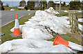
Snow, Ballykeel near Craigantlet (2013-1)
Cleared snow, at a height of about 550ft, at the Ballymiscaw Road end of the Ballyregan Road.
Image: © Albert Bridge
Taken: 9 Apr 2013
0.16 miles
5
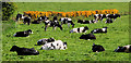
Cattle, Ballymiscaw near Belfast (1)
Part of a herd, grazing in a field, beside the Belfast – Craigantlet road at Ballymiscaw. For another view of the herd, from a slightly different angle, see Image
Image: © Albert Bridge
Taken: 12 May 2010
0.16 miles
6
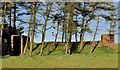
WWII relics near Craigantlet, Belfast (3)
The air raid shelter, close to the Ballymiscaw Road.
Image: © Albert Bridge
Taken: 26 Mar 2012
0.16 miles
7
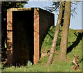
WWII relics near Craigantlet, Belfast (4)
The entrance to the air raid shelter Image, close to the Ballymiscaw Road.
Image: © Albert Bridge
Taken: 26 Mar 2012
0.16 miles
8
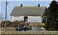
Vacant house, Ballykeel near Craigantlet
A long-vacant and boarded-up bungalow, beside the Ballymiscaw Road, on the south western side of the Church Road. Continue to Image
Image: © Albert Bridge
Taken: 9 Apr 2013
0.16 miles
9

Postbox between Craigantlet and Belfast
Post-mounted EIIR box, in a lay-by at Ballykeel, on the Ballymiscaw Road. Later replaced by a pressed-steel box Image
Image: © Albert Bridge
Taken: 17 Jan 2011
0.16 miles
10
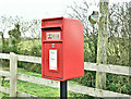
Pressed-steel postbox (BT18 490), Ballykeel, Craigantlet/Belfast (November 2018)
Post-mounted pressed-steel postbox (BT18 490) at the lay-by on the Ballymiscaw Road. It replaced this one Image
Image: © Albert Bridge
Taken: 15 Nov 2018
0.17 miles