IMAGES TAKEN NEAR TO
Harwell Road, HOLYWOOD, BT18 9RL
Introduction
This page details the photographs taken nearby to Harwell Road, BT18 9RL by members of the Geograph project.
The Geograph project started in 2005 with the aim of publishing, organising and preserving representative images for every square kilometre of Great Britain, Ireland and the Isle of Man.

There are currently over 7.5m images from over14,400 individuals and you can help contribute to the project by visiting https://www.geograph.org.uk
Image Map
Images are licensed for reuse under creativecommons.org/licenses/by-sa/2.0
Notes
- Clicking on the map will re-center to the selected point.
- The higher the marker number, the further away the image location is from the centre of the postcode.
Image Listing (9 Images Found)
Images are licensed for reuse under creativecommons.org/licenses/by-sa/2.0
Image
Details
Distance
1
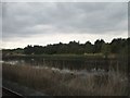
The railway causeway
The causeway is built along the length of a lagoon, with water on either side of the railway.
Image: © Eric Jones
Taken: 21 May 2012
0.16 miles
2
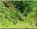
Rabbits near Holywood
Rabbits on land near the Lagoon seen in Image In a short distance I saw well in excess of 20.
Image: © Rossographer
Taken: 4 Jul 2008
0.19 miles
3
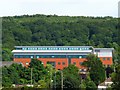
MI5 headquarters Northern Ireland
You won't find this on any OS maps, but nothing evades the all seeing Google satellite. MI5 moved to this building, located deep inside the Palace Barracks complex outside Holywood, in 2007. Close up views are impossible, this is taken from near the Kinnegar in Holywood approximately 1km away.
Image: © Rossographer
Taken: 4 Jul 2008
0.20 miles
4
![Lagoon near Holywood [8]](https://s1.geograph.org.uk/photos/87/45/874585_fe913436_120x120.jpg)
Lagoon near Holywood [8]
After Image, this part of the Lagoon lies south east of the main body of water and is separated by the bridge seen in Image (the water is connected via pipework contained in the bridge). At this point it may be more accurately described as a wetland - the body of water here continues for approximately 1.5km towards Tillysburn. Go back to the start of this sequence of pictures at Image
Image: © Rossographer
Taken: 4 Jul 2008
0.22 miles
5
![Lagoon near Holywood [6]](https://s3.geograph.org.uk/photos/87/45/874575_b649e354_120x120.jpg)
Lagoon near Holywood [6]
After Image, the path around the Lagoon comes to this path which bridges over and cuts the Lagoon in two. The railings would suggest that it was once closed access. Continue on to Image
Image: © Rossographer
Taken: 4 Jul 2008
0.22 miles
6
![Lagoon near Holywood [7]](https://s3.geograph.org.uk/photos/87/45/874579_8d3d5fe8_120x120.jpg)
Lagoon near Holywood [7]
Image: © Rossographer
Taken: 4 Jul 2008
0.24 miles
7
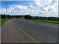
Airport Road West near Belfast
Airport Road West connects the Belfast Harbour Estate with the A2 Belfast-Bangor road near Holywood. The section of road into the harbour estate running from Airport Road dates from, I think, around the 1930s. This section, built on reclaimed land, connects the road to the A2 and was not constructed until the early 1990s (precise clarifications on dates welcomed).
Image: © Rossographer
Taken: 4 Jul 2008
0.24 miles
8
![Lagoon near Holywood [5]](https://s0.geograph.org.uk/photos/87/45/874572_4e71180e_120x120.jpg)
Lagoon near Holywood [5]
Image: © Rossographer
Taken: 4 Jul 2008
0.24 miles
9
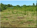
Land near Holywood
After a walk around the Lagoon close to the Kinnegar in Holywood Image, I emerged into this barren patch of ground.
Image: © Rossographer
Taken: 4 Jul 2008
0.25 miles