IMAGES TAKEN NEAR TO
Priors Lea, HOLYWOOD, BT18 9QW
Introduction
This page details the photographs taken nearby to Priors Lea, BT18 9QW by members of the Geograph project.
The Geograph project started in 2005 with the aim of publishing, organising and preserving representative images for every square kilometre of Great Britain, Ireland and the Isle of Man.

There are currently over 7.5m images from over14,400 individuals and you can help contribute to the project by visiting https://www.geograph.org.uk
Image Map
Images are licensed for reuse under creativecommons.org/licenses/by-sa/2.0
Notes
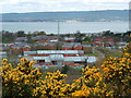
- Clicking on the map will re-center to the selected point.
- The higher the marker number, the further away the image location is from the centre of the postcode.
Image Listing (27 Images Found)
Images are licensed for reuse under creativecommons.org/licenses/by-sa/2.0
Image
Details
Distance
1
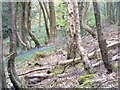
Bluebells in the wood
Part of Redburn Country Park
Image: © Michael Parry
Taken: 27 Apr 2005
0.06 miles
3
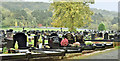
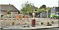
Redburn cemetery, Holywood (October 2017)
Part of Redburn Cemetery, just inside the entrance – built (to the best of my knowledge) on land once part of the Dunville (Redburn) estate Image and Image
Image: © Albert Bridge
Taken: 16 Oct 2017
0.11 miles
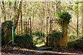
4
Old gate and fence, Redburn, Holywood - March 2014(2)
Image: © Albert Bridge
Taken: 7 Mar 2014
0.12 miles
5
Old gate and fence, Redburn, Holywood - March 2014(3)
See Image Detail from the fence.
Image: © Albert Bridge
Taken: 7 Mar 2014
0.12 miles
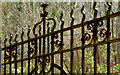
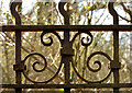
6
Old gate and fence, Redburn, Holywood - March 2014(1)
The remains of a gate, set between crumbling gate posts, in the lower part of Redburn Country Park. It seems reasonable to conclude that they are the sole remains of the now-demolished Redburn House. Further information very welcome. Continue to Image
Image: © Albert Bridge
Taken: 7 Mar 2014
0.13 miles
7
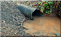
Drain, Redburn, Holywood - March 2014(2)
See Image On the other side of the path where water, collecting in a puddle, is about to flow down the western bank. Positions approximate.
Image: © Albert Bridge
Taken: 7 Mar 2014
0.14 miles
8
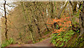
Path, Redburn, Holywood (2)
A path, looking towards Holywood, on the western side of Redburn Country Park. Image shows the view in the opposite direction.
Image: © Albert Bridge
Taken: 31 Jan 2014
0.15 miles
9
No 375 Old Holywood Road, Holywood (June 2019)
Demolished during the past week.
Image: © Albert Bridge
Taken: 8 Jun 2019
0.15 miles
10
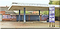
Former car wash, Old Holywood Road, Holywood (October 2017)
A former Maxol petrol station, long closed and, in recent times, used as a car wash. The site had the following planning permission (10 October 2012) “W/2007/0901/F Mixed use development comprising of 2 No ground floor retail units and 8 no. 2 bedroom apartments (amended plans submitted showing addition of boundary fence) Adjacent to 397a Old Holywood Road, Belfast [sic]”.
Image: © Albert Bridge
Taken: 16 Oct 2017
0.15 miles