IMAGES TAKEN NEAR TO
Park Avenue, HOLYWOOD, BT18 9LS
Introduction
This page details the photographs taken nearby to Park Avenue, BT18 9LS by members of the Geograph project.
The Geograph project started in 2005 with the aim of publishing, organising and preserving representative images for every square kilometre of Great Britain, Ireland and the Isle of Man.

There are currently over 7.5m images from over14,400 individuals and you can help contribute to the project by visiting https://www.geograph.org.uk
Image Map
Images are licensed for reuse under creativecommons.org/licenses/by-sa/2.0
Notes
- Clicking on the map will re-center to the selected point.
- The higher the marker number, the further away the image location is from the centre of the postcode.
Image Listing (173 Images Found)
Images are licensed for reuse under creativecommons.org/licenses/by-sa/2.0
Image
Details
Distance
1
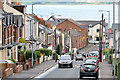
The Downshire Road, Holywood
See Image (February 2006). The steep Downshire Road, from the top, at the corner of the Demesne Road, looking downhill towards the Church Road and Belfast Lough. Image (July 2008) shows a view in the opposite direction.
Image: © Albert Bridge
Taken: 4 Oct 2013
0.04 miles
2
Ardlee Avenue, Holywood (1)
A street running from the Downshire Road (foreground) to My Lady’s Mile. Ardlee Terrace is on the left. See also Image
Image: © Albert Bridge
Taken: 10 Dec 2011
0.06 miles
3
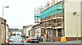
Nos 44-54 Spencer Street, Holywood (April 2018)
Social housing, with scaffolding, during renovation.
Image: © Albert Bridge
Taken: 26 Apr 2018
0.06 miles
4
Ardlee Avenue. Holywood (2)
The name sign on Ardlee Terrace – on the left in Image
Image: © Albert Bridge
Taken: 10 Dec 2011
0.07 miles
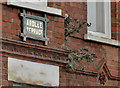
5
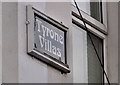
Tyrone Villas sign, Holywood
The name sign, on a terrace on the Downshire Road, between Downshire Place and Church View Image
Image: © Albert Bridge
Taken: 10 Dec 2011
0.09 miles
6
Entry, Holywood
Entry behind Trevor Street in Holywood.
Image: © Rossographer
Taken: 19 Mar 2010
0.11 miles
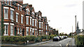
7
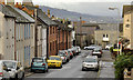
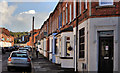
Spencer Street, Holywood
A street, close to the centre of Holywood, lined on both sides by terrace houses in a wide variety of ages and architectural styles. Church View is in the background.
Image: © Albert Bridge
Taken: 10 Dec 2011
0.11 miles
8

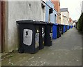
Wheelie bins, Holywood
Image: © Albert Bridge
Taken: 30 Oct 2013
0.12 miles
9
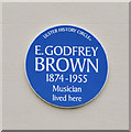
E Godfrey Brown plaque, Holywood
A plaque, on a house on the Downshire Road, commemorating the musician E Godfrey Brown http://www.ulsterhistory.co.uk/brown.html and http://www.byersmusic.com/resources/Godfrey%20Brown.pdf.
Image: © Albert Bridge
Taken: 30 Aug 2013
0.13 miles
10
Trevor Street, Holywood (1)
A street, of terrace houses, on the eastern side of Church View Image Image shows the enamel name sign.
Image: © Albert Bridge
Taken: 18 Sep 2011
0.13 miles