IMAGES TAKEN NEAR TO
The Esplanade, HOLYWOOD, BT18 9JP
Introduction
This page details the photographs taken nearby to The Esplanade, BT18 9JP by members of the Geograph project.
The Geograph project started in 2005 with the aim of publishing, organising and preserving representative images for every square kilometre of Great Britain, Ireland and the Isle of Man.

There are currently over 7.5m images from over14,400 individuals and you can help contribute to the project by visiting https://www.geograph.org.uk
Image Map
Images are licensed for reuse under creativecommons.org/licenses/by-sa/2.0
Notes
- Clicking on the map will re-center to the selected point.
- The higher the marker number, the further away the image location is from the centre of the postcode.
Image Listing (78 Images Found)
Images are licensed for reuse under creativecommons.org/licenses/by-sa/2.0
Image
Details
Distance
1
Flooded path, Holywood (1)
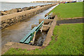
14.35 – this part of the North Down coastal path has holes in the seawall to allow surplus rainwater to drain into Belfast Lough. Today, with the tide exceptionally high, the path had flooded
Image: © Albert Bridge
Taken: 6 Jan 2014
0.02 miles
2
Kinnegar Road, Holywood
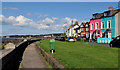
A street, running from Kinnegar Avenue (behind me) to The Esplanade, with uninterrupted views over Belfast Lough. Shown as Kinnegar Road on the OS street map and The Esplanade on the Google map.
Image: © Albert Bridge
Taken: 16 Aug 2011
0.03 miles
3
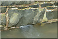
Survey mark, Holywood - January 2015(1)
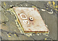
A survey mark, attached to the rock armour Image, at The Esplanade.
Image: © Albert Bridge
Taken: 5 Jan 2015
0.03 miles
4
Survey mark, Holywood - January 2015(2)
A survey mark, attached to the rock armour Image, at The Esplanade.
Image: © Albert Bridge
Taken: 5 Jan 2015
0.03 miles
5
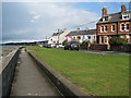
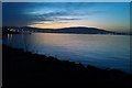
The Esplanade, Kinnegar, Holywood
The Kinnegar area of Holywood was separated from the rest of the town by the railway and, latterly, the Holywood bypass. This is part of 'The Esplanade' which has fine views out across Belfast Lough.
Image: © Rossographer
Taken: 11 Apr 2008
0.03 miles
6
Flooded path, Holywood (2)
14.36 - this part of the North Down coastal path has holes in the seawall to allow surplus rainwater to drain into Belfast Lough. Today, with the tide exceptionally high, the seawater was coming in to flood the path.
Image: © Albert Bridge
Taken: 6 Jan 2014
0.03 miles
7
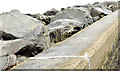
Sea defences, Holywood (January 2015)
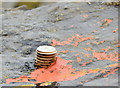
Rock armour sea defences, along the shore of Belfast Lough, at The Esplanade, Holywood. They counter coastal erosion but not flooding Image Previously seen in Image (May 2012).
Image: © Albert Bridge
Taken: 5 Jan 2015
0.04 miles
8
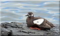
Black guillemot, Holywood (August 2015)
An almost mature black guillemot http://www.rspb.org.uk/discoverandenjoynature/discoverandlearn/birdguide/name/b/blackguillemot/ , on the shore of Belfast Lough, at Kinnegar. The plumage varies according to age. For other photographs see http://www.geograph.org.uk/of/black+guillemot.
Image: © Albert Bridge
Taken: 12 Aug 2015
0.04 miles
9
Belfast hills from Holywood
Taken 8th January 2014
Image: © John Thompson
Taken: 8 Jan 2014
0.04 miles
10

EI-DVL over Kinnegar, Holywood (February 2016)
Aer Lingus Airbus A320 (EI-DVL) http://www.geograph.org.uk/of/EI-DVL passing over Kinnegar, on final approach to Belfast City Airport.
Image: © Albert Bridge
Taken: 10 Feb 2016
0.05 miles