IMAGES TAKEN NEAR TO
Martello Gate, HOLYWOOD, BT18 9GE

Introduction

This page details the photographs taken nearby to Martello Gate, BT18 9GE by members of the Geograph project.

The Geograph project started in 2005 with the aim of publishing, organising and preserving representative images for every square kilometre of Great Britain, Ireland and the Isle of Man.

There are currently over 7.5m images from over14,400 individuals and you can help contribute to the project by visiting https://www.geograph.org.uk

Image Map


Images are licensed for reuse under creativecommons.org/licenses/by-sa/2.0
Notes
  • Clicking on the map will re-center to the selected point.
  • The higher the marker number, the further away the image location is from the centre of the postcode.

Image Listing (145 Images Found)

Images are licensed for reuse under creativecommons.org/licenses/by-sa/2.0
  • ...
Image
Details
Distance
1
Victoria Road, Holywood (2)
See Image Further along the road, the first in a series of bends, as it climbs towards the Croft Road. Continue to Image (February 2014).
Image: © Albert Bridge Taken: 2 Mar 2012
0.04 miles
2
Old windmill, Holywood
The remains of an old windmill in Holywood it is located off Victoria Road beside Martello Terrace. I can't find much information other than it was owned by a William Patton in the mid 19th Century.
Image: © Rossographer Taken: 10 Jun 2008
0.05 miles
3
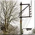
Telegraph pole, Holywood
Metal telegraph poles are not too common. I don’t remember seeing one with the insulators attached to a rectangular bracket. This example is further up the Victoria Road from here Image
Image: © Albert Bridge Taken: 2 Mar 2012
0.05 miles
4
Twisel Burn, Holywood
Twisel Burn in Holywood. The wall and path were built at the same time as nearby Twisel Bridge - see Image The water level low after two months of very dry weather, the burn is prone to severe flooding. In June 1999 the river level rose some 12 feet above normal after a particularly severe flash flood, devasting nearby homes.
Image: © Rossographer Taken: 10 Jun 2008
0.08 miles
5
Path by Twisel Burn, Holywood
The path alongside Twisel Burn in Holywood. Looking in the direction of Twisel Bridge - Image
Image: © Rossographer Taken: 10 Jun 2008
0.09 miles
6
Valerian, Holywood
Valerian (the first I’ve seen in 2012) growing along the Victoria Road Image
Image: © Albert Bridge Taken: 27 Apr 2012
0.09 miles
7
Glynwed Brickhouse "Valiant" access cover, Holywood
A Glynwed Brickhouse “Valiant” http://www.geograph.org.uk/search.php?i=30855228 access cover, on the Victoria Road, at the top of the steps to the Twisel Bridge.
Image: © Albert Bridge Taken: 27 Apr 2012
0.10 miles
8
The Twisel Bridge, Holywood (1)
The Twisel Bridge, described in Image (June 2008), seen from the steps Image from the Victoria Road. Image shows a ground-level view.
Image: © Albert Bridge Taken: 27 Apr 2012
0.11 miles
9
The Twisel Bridge, Holywood (2)
See Image The bridge from ground level. The Twisel Burn is flowing from left to right. Image shows the view in the opposite direction.
Image: © Albert Bridge Taken: 27 Apr 2012
0.11 miles
10
Steps, Holywood
Steps, leading from the Victoria Road (top), to the Twisel Bridge Image and the Twisel Burn.
Image: © Albert Bridge Taken: 27 Apr 2012
0.11 miles
  • ...