IMAGES TAKEN NEAR TO
Crofton Glen, HOLYWOOD, BT18 0QF
Introduction
This page details the photographs taken nearby to Crofton Glen, BT18 0QF by members of the Geograph project.
The Geograph project started in 2005 with the aim of publishing, organising and preserving representative images for every square kilometre of Great Britain, Ireland and the Isle of Man.

There are currently over 7.5m images from over14,400 individuals and you can help contribute to the project by visiting https://www.geograph.org.uk
Image Map
Images are licensed for reuse under creativecommons.org/licenses/by-sa/2.0
Notes
- Clicking on the map will re-center to the selected point.
- The higher the marker number, the further away the image location is from the centre of the postcode.
Image Listing (126 Images Found)
Images are licensed for reuse under creativecommons.org/licenses/by-sa/2.0
Image
Details
Distance
1
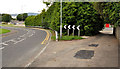
The Croft Road, Holywood
A downhill continuation, from Whinney Hill Image and the Creighton’s Green Road Image Image, towards the Bangor Road at the end of the bypass Image (to the left of the hedge). Continue to Image
Image: © Albert Bridge
Taken: 9 Aug 2011
0.03 miles
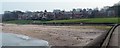
3
The old mill, Holywood
This is at the rear of Martello Terrace, off Victoria Road.
Image: © Roger Miller
Taken: 11 Aug 2006
0.03 miles
4
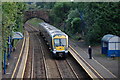
Marino station, Northern Ireland Railways
Marino station opened in 1869 and closed in 1957. It re-opened in 1960. In common with other intermediate stations on the Belfast-Bangor line it is quiet outside the peak periods. The 11.20 Bangor-Lisburn is stopping as one passenger waits to board. This is an area of low density housing with multiple car ownership – not the sort of place to generate business for public transport.
Image: © Albert Bridge
Taken: 25 Sep 2006
0.03 miles
5
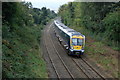
Approaching Marino station
See Image The train is the 10.30 Portadown-Bangor approaching Marino station. It is ascending the Holywood bank – a notorious ascent in the days of steam but light work for the latest generation of diesel units.
Image: © Albert Bridge
Taken: 25 Sep 2006
0.03 miles
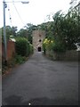
6
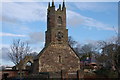
The Priory, Holywood
The remains of the church seen from High Street.
Image: © Albert Bridge
Taken: 21 Feb 2007
0.03 miles
7
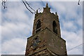
The Priory, Holywood (detail)
See Image This is the tower. The clock is not in working order.
Image: © Albert Bridge
Taken: 21 Feb 2007
0.03 miles
8

Railway Bridge
Railway bridge at Marino Station looking towards Bangor
Image: © Wilson Adams
Taken: 27 Aug 2005
0.03 miles
9
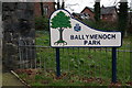
Sign near Holywood
North Down Council is an expert at providing attractive signs in its parks. This one is at the entrance to Ballymenoch Park, on the Bangor road, just outside Holywood.
Image: © Albert Bridge
Taken: 5 Mar 2007
0.03 miles
10
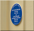
Rosamund and Lloyd Praeger plaque, Holywood
A plaque jointly commemorating Rosamund and Lloyd Praeger http://www.ulsterhistory.co.uk/robertlloydpraeger.htm. See also http://www.geograph.org.uk/search.php?i=48109735. I have withheld the grid reference and address in common with the descriptions in the Ulster History Circle website. The comments in Image apply here too.
Image: © Albert Bridge
Taken: 8 Apr 2014
0.03 miles