1
View south-eastwards along Seapark Road from the edge of the beach
The road junction in the foreground is that with Ballymenoch Park. A railway bridge can be seen in the distance.
Image: © Eric Jones
Taken: 20 May 2012
0.02 miles
2
Sinclair access cover, Holywood
A double Sinclair access cover, close to the shore on the Seapark Road. The Sinclair Iron co of Wellington, Shropshire seems to have been founded in the middle of the 18th century. It passed through successive owners, possibly reaching its peak in the mid-1960’s when it had more than 1,200 employees. It later became part of Glynwed Brickhouse, Dudley. http://www.geograph.org.uk/search.php?i=23551641 shows other Brickhouse products.
Image: © Albert Bridge
Taken: 30 Jul 2011
0.03 miles
3
Bowling green, Holywood (1)
The north western end of the bowling green at Seapark recreation grounds
Image Used by Holywood Bowling Club. See also
Image
Image: © Albert Bridge
Taken: 20 Dec 2011
0.03 miles
4
Coastal mist, Seapark, Holywood - January 2016(1)
The view, towards Holywood, along the North Down Coastal Path (Seapark Avenue on the Google map) at the end of the Seapark Road
Image The sun was making a valiant attempt to break through the mist.
Image: © Albert Bridge
Taken: 20 Jan 2016
0.03 miles
5
Adams manhole cover, Holywood
A manhole cover, on the Seapark Road, from the York foundry of Adams Ltd http://www.geograph.org.uk/search.php?i=23839928
Image: © Albert Bridge
Taken: 9 Aug 2011
0.03 miles
6
Bowling green, Holywood (2)
See
Image The south eastern end of the bowling green at Seapark recreation grounds
Image Used by Holywood Bowling Club.
Image: © Albert Bridge
Taken: 20 Dec 2011
0.03 miles
7
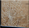
Spider's web, Seapark, Holywood (January 2016)
A spider’s web, on the North Down Coastal Path fence at the end of the Seapark Road, lit by the sun breaking through the mist - see
Image
Image: © Albert Bridge
Taken: 20 Jan 2016
0.03 miles
8
The Seapark Road stretch of the Coastal Path
Image: © Eric Jones
Taken: 20 May 2012
0.04 miles
9
Seapark Terrace, Holywood
A short street, off the Seapark Road, which includes a three-storey terrace (left).
Image: © Albert Bridge
Taken: 9 Aug 2011
0.04 miles
10
Coastal mist, Seapark, Holywood - January 2016(3)
See
Image Just four minutes later, looking along the North Down Coastal Path towards Cultra, as the sun was breaking through the mist. Belfast Lough remains hidden in the background.
Image: © Albert Bridge
Taken: 20 Jan 2016
0.05 miles


