IMAGES TAKEN NEAR TO
Seapark Lane, HOLYWOOD, BT18 0LA
Introduction
This page details the photographs taken nearby to Seapark Lane, BT18 0LA by members of the Geograph project.
The Geograph project started in 2005 with the aim of publishing, organising and preserving representative images for every square kilometre of Great Britain, Ireland and the Isle of Man.

There are currently over 7.5m images from over14,400 individuals and you can help contribute to the project by visiting https://www.geograph.org.uk
Image Map
Images are licensed for reuse under creativecommons.org/licenses/by-sa/2.0
Notes
- Clicking on the map will re-center to the selected point.
- The higher the marker number, the further away the image location is from the centre of the postcode.
Image Listing (102 Images Found)
Images are licensed for reuse under creativecommons.org/licenses/by-sa/2.0
Image
Details
Distance
1
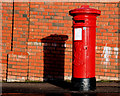
Pillar box, Holywood
EVIIR pillar box at the Bangor Road end of the Seapark Road. There is bracket on the top which might have held an arrow pointing to the nearest post office.
Image: © Albert Bridge
Taken: 21 Jan 2011
0.03 miles
2
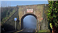
Misty railway bridge, Seapark, Holywood (January 2016)
Today’s early fog was slow to clear. Much of the area around Belfast Lough remained covered until after 11.30am. This bridge carries the Belfast (left) – Bangor railway across the Seapark Road.
Image: © Albert Bridge
Taken: 20 Jan 2016
0.05 miles
3
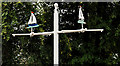
Weathervane, Holywood
Double weathervane, in the form of two yachts (not pointing in the same direction during a calm period), at the entrance to Ballymenoch Park on the Bangor Road.
Image: © Albert Bridge
Taken: 30 Jul 2011
0.05 miles
4
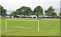
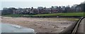
Playing fields, Seapark, Holywood (2013-1)
A football pitch and all-weather tennis courts at the south eastern end of the Seapark Recreation Grounds. Belfast Lough is in the background. See also Image
Image: © Albert Bridge
Taken: 20 Aug 2013
0.06 miles
5
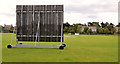
Cricket pitch, Holywood
Side screen and cricket pitch at the Seapark playing fields Image on the Seapark Road.
Image: © Albert Bridge
Taken: 9 Aug 2011
0.07 miles
6

Poppies, Holywood
Part of a display of poppies at the entrance to Ballymenoch Park, on the Bangor Road.
Image: © Albert Bridge
Taken: 30 Jul 2011
0.07 miles
7
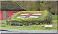
Lifeboat flowerbed, Holywood (January 2015)
A few minutes before noon on New Year’s Day, the RNLI flag on display at Ballymenoch Park, on the Bangor Road.
Image: © Albert Bridge
Taken: 1 Jan 2015
0.07 miles
8
The Croft Road, Holywood
A downhill continuation, from Whinney Hill Image and the Creighton’s Green Road Image Image, towards the Bangor Road at the end of the bypass Image (to the left of the hedge). Continue to Image
Image: © Albert Bridge
Taken: 9 Aug 2011
0.08 miles
9
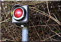
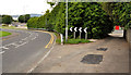
Red light, Seapark, Holywood
A post-mounted red light (not vandalised and apparently in working order), at the left-hand bend where Ballymenoch Park becomes Seapark Grove. My first thought was that it might be a navigation light for Belfast Lough but, if it is/was, the view would be blocked by trees. The railway embankment, between Holywood and Marino stations, is in the background.
Image: © Albert Bridge
Taken: 20 Aug 2013
0.08 miles