IMAGES TAKEN NEAR TO
Larch Hill, HOLYWOOD, BT18 0JN
Introduction
This page details the photographs taken nearby to Larch Hill, BT18 0JN by members of the Geograph project.
The Geograph project started in 2005 with the aim of publishing, organising and preserving representative images for every square kilometre of Great Britain, Ireland and the Isle of Man.

There are currently over 7.5m images from over14,400 individuals and you can help contribute to the project by visiting https://www.geograph.org.uk
Image Map
Images are licensed for reuse under creativecommons.org/licenses/by-sa/2.0
Notes
- Clicking on the map will re-center to the selected point.
- The higher the marker number, the further away the image location is from the centre of the postcode.
Image Listing (11 Images Found)
Images are licensed for reuse under creativecommons.org/licenses/by-sa/2.0
Image
Details
Distance
1
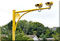
Speed cameras, Craigavad
Average-speed cameras, on the Belfast-bound lanes of the Bangor Road, near Larch Hill, on the Belfast side of the Devil’s Elbow Image One of several in use along the road – see also Image Fixed speed cameras are very rare in NI.
Image: © Albert Bridge
Taken: 20 Aug 2013
0.08 miles
2
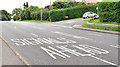
Road markings, Craigavad
Road markings, on the Bangor Road at Larch Hill, in advance of the Seahill Road traffic lights at the Devil’s Elbow Image
Image: © Albert Bridge
Taken: 20 Aug 2013
0.09 miles
3
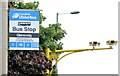
Bus stop, Craigavad
The “Glencraig” stop, on the Bangor Road, near Larch Hill. The Bangor-bound average-speed camera Image is in the background.
Image: © Albert Bridge
Taken: 20 Aug 2013
0.11 miles
4
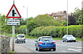
"Side road ahead" sign, Craigavad
This part of the Bangor Road, which includes the Devil’s Elbow Image, is twisting with no right-turn bays. The junction with Larch Hill is well signposted to give drivers an opportunity to move into the correct lane.
Image: © Albert Bridge
Taken: 20 Aug 2013
0.12 miles
5
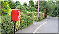
Letter box, Craigavad
Post-mounted EIIR letter box (BT18 652) at the Holywood end of Glencraig Park.
Image: © Albert Bridge
Taken: 20 Aug 2013
0.17 miles
6

Ground frame and hut, Rockport, Craigavad
In the period after the re-connection of the Bangor line to the rest of the Irish railways Image Image and before the relaying of the line in 2001/02 http://www.geograph.org.uk/search.php?i=33501286 there was an emergency trailing crossover at Rockport, approximately halfway between Seahill and the closed station at Craigavad. It was controlled by a ground frame just visible beside the hut.
Image: © Albert Bridge
Taken: 9 Jun 1985
0.21 miles
7
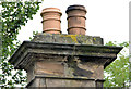
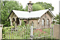
Disused gate lodge, Craigavad (2013-3)
A sandstone chimney with two identical pots one of which seems to show little sign of the effects of soot. The photograph, in “The Gate Lodges of Ulster”, taken when the lodge was occupied, shows only one pot.
Image: © Albert Bridge
Taken: 20 Aug 2013
0.23 miles
8
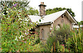
Disused gate lodge, Craigavad (2013-1)
The lodge, seen from the Bangor Road, now partly hidden behind a growth of vegetation.
Image: © Albert Bridge
Taken: 20 Aug 2013
0.23 miles
9
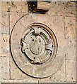
Disused gate lodge, Craigavad (2013-2)
Architectural detail on the gable facing the Bangor Road. The scallop was, apparently, a symbol used by the Mulholland family one-time owners of the estate.
Image: © Albert Bridge
Taken: 20 Aug 2013
0.23 miles
10
Old gate lodge, Craigavad (May 2017)
Still vacant but the vegetation seems to have been cut back.
Image: © Albert Bridge
Taken: 25 May 2017
0.23 miles