IMAGES TAKEN NEAR TO
Ballymenoch Road, HOLYWOOD, BT18 0HN
Introduction
This page details the photographs taken nearby to Ballymenoch Road, BT18 0HN by members of the Geograph project.
The Geograph project started in 2005 with the aim of publishing, organising and preserving representative images for every square kilometre of Great Britain, Ireland and the Isle of Man.

There are currently over 7.5m images from over14,400 individuals and you can help contribute to the project by visiting https://www.geograph.org.uk
Image Map
Images are licensed for reuse under creativecommons.org/licenses/by-sa/2.0
Notes
- Clicking on the map will re-center to the selected point.
- The higher the marker number, the further away the image location is from the centre of the postcode.
Image Listing (4 Images Found)
Images are licensed for reuse under creativecommons.org/licenses/by-sa/2.0
Image
Details
Distance
1
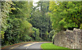
Whinney Hill, Holywood (1)
The view from close to the corner of Carlston Avenue, as Whinney Hill makes its steep and twisting descent towards the main road at Marino.
Image: © Albert Bridge
Taken: 1 Oct 2013
0.14 miles
2
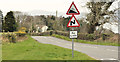
Whinney Hill, Holywood - March 2014(1)
Whinney Hill, looking down into Holywood, close to the start of the 30mph zone. The gradient is shown as 15% which is roughly 1 in 7 under the old system.
Image: © Albert Bridge
Taken: 25 Mar 2014
0.22 miles
3
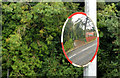
Traffic mirror, Holywood
A sighting mirror, at one of the many bends along Whinney Hill Image, close to the corner of Dalwhinney Road.
Image: © Albert Bridge
Taken: 1 Oct 2013
0.23 miles
4
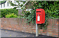
Letter box, Holywood
Post-mounted EIIR letter box (BT18 29) at Dalwhinney Road (off Whinney Hill).
Image: © Albert Bridge
Taken: 1 Oct 2013
0.23 miles