IMAGES TAKEN NEAR TO
Craigavad Park, HOLYWOOD, BT18 0GH
Introduction
This page details the photographs taken nearby to Craigavad Park, BT18 0GH by members of the Geograph project.
The Geograph project started in 2005 with the aim of publishing, organising and preserving representative images for every square kilometre of Great Britain, Ireland and the Isle of Man.

There are currently over 7.5m images from over14,400 individuals and you can help contribute to the project by visiting https://www.geograph.org.uk
Image Map
Images are licensed for reuse under creativecommons.org/licenses/by-sa/2.0
Notes
- Clicking on the map will re-center to the selected point.
- The higher the marker number, the further away the image location is from the centre of the postcode.
Image Listing (22 Images Found)
Images are licensed for reuse under creativecommons.org/licenses/by-sa/2.0
Image
Details
Distance
1
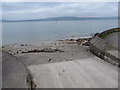
Slipway at the junction of Station Road and Frenchwood Park
Image: © Eric Jones
Taken: 20 May 2012
0.22 miles
2
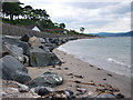
Seaweed, Cultra (3)
Part of an accumulation of seaweed, on the small slipway opposite the Station Road, probably washed ashore by a combination of the spring tide and the wind. Parts of the coastal path had a thick (and slippery) coating of seaweed today.
Image: © Albert Bridge
Taken: 2 Oct 2012
0.22 miles
3
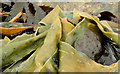
Seaweed, Cultra (4)
Part of an accumulation of seaweed, on the small slipway opposite the Station Road, probably washed ashore by a combination of the spring tide and the wind. Parts of the coastal path had a thick (and slippery) coating of seaweed today.
Image: © Albert Bridge
Taken: 2 Oct 2012
0.22 miles
4
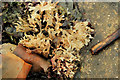
Seaweed, Cultra (5)
Part of an accumulation of seaweed, on the small slipway opposite the Station Road, probably washed ashore by a combination of the spring tide and the wind. Parts of the coastal path had a thick (and slippery) coating of seaweed today.
Image: © Albert Bridge
Taken: 2 Oct 2012
0.22 miles
5
View west along Station Road
This is a private road although access is allowed for pedestrians.
Image: © Eric Jones
Taken: 20 May 2012
0.22 miles
6
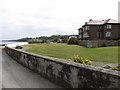
Villa on Station Road
This overlooks Belfast Lough. Station Road is a private road.
Image: © Eric Jones
Taken: 20 May 2012
0.22 miles
7
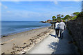
A walk in the sun
Walkers enjoy a stroll in the warm April sunshine near Cultra.
Image: © Robert Ashby
Taken: 30 Apr 2014
0.22 miles
8
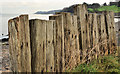
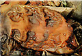
Old railway sleepers, Cultra/Craigavad
A line of old railway sleepers, on the Bangor side of Image, shoring part of the North Down coastal path.
Image: © Albert Bridge
Taken: 16 Jan 2012
0.22 miles
9
The North Down Coastal Path, Craigavad
The coastal path at Craigavad. The path at this point follows Station Road as, here at high tide, the shoreline is underwater. This is the view towards Cultra.
Image: © Rossographer
Taken: 16 Jun 2010
0.22 miles
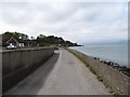
10
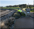
The North Down Coastal Path at Craigavad
The path as it leaves Station Road at Craigavad and proceeds between Royal Belfast Golf Course and the shoreline. Four cyclists passed me as I was taking the picture, proceeding in single file towards Bangor.
Image: © Rossographer
Taken: 30 Jan 2023
0.22 miles