IMAGES TAKEN NEAR TO
Bangor Road, HOLYWOOD, BT18 0EZ
Introduction
This page details the photographs taken nearby to Bangor Road, BT18 0EZ by members of the Geograph project.
The Geograph project started in 2005 with the aim of publishing, organising and preserving representative images for every square kilometre of Great Britain, Ireland and the Isle of Man.

There are currently over 7.5m images from over14,400 individuals and you can help contribute to the project by visiting https://www.geograph.org.uk
Image Map
Images are licensed for reuse under creativecommons.org/licenses/by-sa/2.0
Notes
- Clicking on the map will re-center to the selected point.
- The higher the marker number, the further away the image location is from the centre of the postcode.
Image Listing (41 Images Found)
Images are licensed for reuse under creativecommons.org/licenses/by-sa/2.0
Image
Details
Distance
1
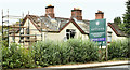
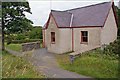
Glen Cottages, Cultra (October 2019)
Now being advertised as “Two charming cottages with significant restoration”.
Image: © Albert Bridge
Taken: 3 Oct 2019
0.02 miles
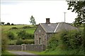
2
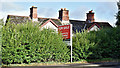
Glen Cottages development site, Cultra (October 2017)
The cottages, mainly hidden behind a high hedge.
Image: © Albert Bridge
Taken: 5 Oct 2017
0.02 miles
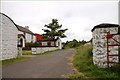
3
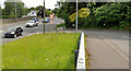
The Ballygrainey Road, Craigavad (2)
The Ballygrainey Road (Bangor Road on the Google map) Image, at the end of its journey from Whinney Hill Image, on the Bangor – Belfast road near the Devil’s Elbow.
Image: © Albert Bridge
Taken: 20 Jun 2012
0.08 miles
4
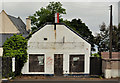
Disused shop, Craigavad
A long-disused shop (probably since before the boom before the recession) on the Bangor Road, opposite the Ballygrainey Road Image Continue to Image
Image: © Albert Bridge
Taken: 20 Jun 2012
0.08 miles
5
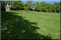
The Ulster Folk Museum (5)
See Image This bleach green water tower came from Tullylish between Banbridge and Gilford. It was used by a watchman to prevent theft of the bleaching linen and to ensure that it was not damaged by grazing animals.
Image: © Albert Bridge
Taken: 21 May 2007
0.10 miles
6
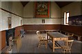
The Ulster Folk Museum (20)
See Image The Worshipful Master’s view of the hall. The Lodge’s banner depicting the flight of King James from the Battle of the Boyne is hung on the rear wall. When the lodge was in session a tyler would have been on duty to ensure that only members entered the room.
Image: © Albert Bridge
Taken: 4 Aug 2007
0.10 miles
7
The Ulster Folk Museum (19)
See Image The Hand & Pen orange hall came from Co Monaghan. It was built in 1884. It is unusual in that most halls are named after the townland or a notable local personality. This one is said to have been named after a sign on a local shop. It was home to LOL 597.
Image: © Albert Bridge
Taken: 4 Aug 2007
0.10 miles
8
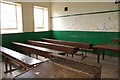
The Ulster Folk Museum (18)
See Image The teacher’s view of part of the classroom (“Please Miss I haftae help me Da the marra wi tha potata gatherin’”).
Image: © Albert Bridge
Taken: 4 Aug 2007
0.10 miles
9
The Ulster Folk Museum (17)
See Image Ballydown national school came from near Banbridge in Co Down. Built in 1865 it had 100 children on its roll. For a (part) view of the present school at Ballydown see Image
Image: © Albert Bridge
Taken: 4 Aug 2007
0.10 miles
10
The Ulster Folk Museum (16)
See Image The farmhouse in its roadside setting. It looks exactly accurate except that there is no farmer to suggest that the photographer is a burglar (and no barking dog).
Image: © Albert Bridge
Taken: 4 Aug 2007
0.10 miles