IMAGES TAKEN NEAR TO
Ballymenoch Lane, HOLYWOOD, BT18 0EF
Introduction
This page details the photographs taken nearby to Ballymenoch Lane, BT18 0EF by members of the Geograph project.
The Geograph project started in 2005 with the aim of publishing, organising and preserving representative images for every square kilometre of Great Britain, Ireland and the Isle of Man.

There are currently over 7.5m images from over14,400 individuals and you can help contribute to the project by visiting https://www.geograph.org.uk
Image Map
Images are licensed for reuse under creativecommons.org/licenses/by-sa/2.0
Notes
- Clicking on the map will re-center to the selected point.
- The higher the marker number, the further away the image location is from the centre of the postcode.
Image Listing (3 Images Found)
Images are licensed for reuse under creativecommons.org/licenses/by-sa/2.0
Image
Details
Distance
1
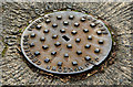
McKeown's manhole cover, Holywood
A well-preserved McKeown’s Grosvenor Foundry http://www.geograph.org.uk/search.php?i=45002653 manhole cover near the Woodlands entrance to Ballymenoch Park.
Image: © Albert Bridge
Taken: 8 Nov 2013
0.22 miles
2
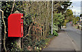
Letter box, Holywood (1-1)
EIIR letter box (BT18 702), on the Croft Road opposite Woodgrange (Woodbank Lane on the Google map). It can be seen at bottom left in Image Image shows the sticker giving the new times for the final collections.
Image: © Albert Bridge
Taken: 27 Apr 2012
0.25 miles
3
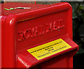
Letter box, Holywood (1-2)
See Image The sticker showing the new times for the last collections.
Image: © Albert Bridge
Taken: 27 Apr 2012
0.25 miles