IMAGES TAKEN NEAR TO
Seahill Road, HOLYWOOD, BT18 0DW
Introduction
This page details the photographs taken nearby to Seahill Road, BT18 0DW by members of the Geograph project.
The Geograph project started in 2005 with the aim of publishing, organising and preserving representative images for every square kilometre of Great Britain, Ireland and the Isle of Man.

There are currently over 7.5m images from over14,400 individuals and you can help contribute to the project by visiting https://www.geograph.org.uk
Image Map
Images are licensed for reuse under creativecommons.org/licenses/by-sa/2.0
Notes
- Clicking on the map will re-center to the selected point.
- The higher the marker number, the further away the image location is from the centre of the postcode.
Image Listing (4 Images Found)
Images are licensed for reuse under creativecommons.org/licenses/by-sa/2.0
Image
Details
Distance
1
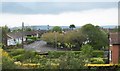
The junction of Craigdarragh Park and Craigowen Road at Ballyrobert
Image: © Eric Jones
Taken: 21 May 2012
0.15 miles
2
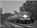
Train approaching Seahill station - 1988
One of NIR's 80-class sets approaches Seahill station with the 16.55 Bangor - Portadown passenger service.
Opened by the UTA in 1966, Seahill station is a nondescript affair with limited photographic potential. For a 2006 view of the station, see: Image] .
Image: © The Carlisle Kid
Taken: 7 Aug 1988
0.19 miles
3
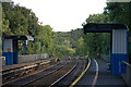
Seahill station, Northern Ireland Railways
Seahill station, on the Belfast-Bangor line, was opened by the UTA in 1966 to cater for new and proposed developments in the area. Some might describe it as a surprising move given the UTA’s reputation for doing little to further the interests of the railway. The structures are basic comprising bus-style shelters. This is the view in the down direction (towards Bangor).
Image: © Albert Bridge
Taken: 19 Sep 2006
0.25 miles
4
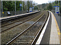
Seahill Railway halt
Seahill halt on the Bangor-Belfast railway line. Looking in the Bangor direction.
Image: © Rossographer
Taken: 3 Apr 2008
0.25 miles