IMAGES TAKEN NEAR TO
Seafront Road, HOLYWOOD, BT18 0BB
Introduction
This page details the photographs taken nearby to Seafront Road, BT18 0BB by members of the Geograph project.
The Geograph project started in 2005 with the aim of publishing, organising and preserving representative images for every square kilometre of Great Britain, Ireland and the Isle of Man.

There are currently over 7.5m images from over14,400 individuals and you can help contribute to the project by visiting https://www.geograph.org.uk
Image Map
Images are licensed for reuse under creativecommons.org/licenses/by-sa/2.0
Notes
- Clicking on the map will re-center to the selected point.
- The higher the marker number, the further away the image location is from the centre of the postcode.
Image Listing (69 Images Found)
Images are licensed for reuse under creativecommons.org/licenses/by-sa/2.0
Image
Details
Distance
1
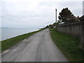
Seafront Road, Cultra
The North Down Path runs along this private road.
Image: © Eric Jones
Taken: 20 May 2012
0.01 miles
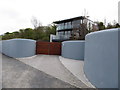
2
Building site, Cultra (September 2014)
A building site, on the Seafront Road, with a “sold” sign. The agents’ brochure described it as follows: “Outline Planning Permission was granted on 22 January 2010 for a detached dwelling of circa 5,800 sq ft. (Ref: W/2009/O472).” This photograph appears as a matter of geographical and historical record only. I have no connection with any of the parties involved in the sale.
Image: © Albert Bridge
Taken: 8 Sep 2014
0.02 miles

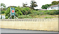
4
The Richmond Nursing Home, Cultra
This building on Seafront Road overlooks Belfast Lough.
Image: © Eric Jones
Taken: 20 May 2012
0.04 miles
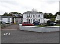
6
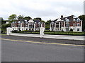
Apartment blocks at Clanbrassil Court, Seafront Road, Cultra
Image: © Eric Jones
Taken: 20 May 2012
0.05 miles
7
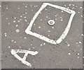
Survey mark, Cultra (June 2015)
A survey point marker on the Seafront Road Image
Image: © Albert Bridge
Taken: 4 Jun 2015
0.07 miles
8
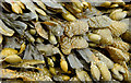
Seaweed, Cultra (June 2014)
Seaweed, possibly washed in by the recent spring tide, below the Seafront Road close to here Image
Image: © Albert Bridge
Taken: 14 Jun 2014
0.07 miles
9
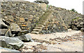
Steps, Cultra
Stone steps leading from the Seafront Road to the loughshore.
Image: © Albert Bridge
Taken: 14 Jun 2014
0.08 miles
10
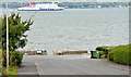
The Seafront Road, Cultra (September 2014)
See Image (January 2013). The seaward end of the road, approaching the loughshore. The “Stena Superfast VII” is passing with the 11.30 sailing to Cairnryan. The road on the right is private but also includes a section of the public North Down Coastal Path to Bangor and Groomsport.
Image: © Albert Bridge
Taken: 8 Sep 2014
0.09 miles