IMAGES TAKEN NEAR TO
Church Avenue, BELFAST, BT17 9RS

Introduction

This page details the photographs taken nearby to Church Avenue, BT17 9RS by members of the Geograph project.

The Geograph project started in 2005 with the aim of publishing, organising and preserving representative images for every square kilometre of Great Britain, Ireland and the Isle of Man.

There are currently over 7.5m images from over14,400 individuals and you can help contribute to the project by visiting https://www.geograph.org.uk

Image Map


Images are licensed for reuse under creativecommons.org/licenses/by-sa/2.0
Notes
  • Clicking on the map will re-center to the selected point.
  • The higher the marker number, the further away the image location is from the centre of the postcode.

Image Listing (214 Images Found)

Images are licensed for reuse under creativecommons.org/licenses/by-sa/2.0
  • ...
Image
Details
Distance
1
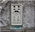
Flush Bracket, Dunmurry
Flush bracket on the western side of St Colman's Parish Church on Church Avenue, Dunmurry. The number on the bracket is OSNIBM 1021. The mark is 35.07 metres above MSL. A flush bracket is a type of bench mark set onto the face of a building. See also http://www.geograph.org.uk/search.php?i=11037856 for many other examples I have found.
Image: © Rossographer Taken: 28 Apr 2010
0.03 miles
2
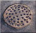
Manhole cover, Dunmurry
Manhole cover on Church Avenue, Dunmurry. It is marked "Adams Ltd., York". I can't find too much out about Adams Limited, but they appear to have been involved in the water and sewage treatment industry and may still be trading as Ham Baker Adams / Adams Hydraulics - http://www.adamshydraulics.co.uk/ . Clarifications on the above welcomed. See also Image
Image: © Rossographer Taken: 22 Mar 2011
0.04 miles
3
Post Office Telephones cover, Dunmurry
Detail of an access cover for telephone cables located on Church Avenue, Dunmurry. It is marked "Post Office Telephones" which is fairly uncommon - most similar covers are just marked with a "PO".
Image: © Rossographer Taken: 22 Mar 2011
0.05 miles
4
Seat, Dunmurry
A seat, overlooking Kingsway Image (behind me), covered by frozen snow.
Image: © Albert Bridge Taken: 7 Dec 2010
0.05 miles
5
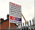
Development site, Dunmurry (1)
A vacant site, at Dunmurry Lane, offered for sale and described on the agents’ board Image as “Commercial/residential opportunity (subject to planning)”. See also Image and Image This photograph appears as a matter of record only. I have no connection with any of the parties involved in the sale.
Image: © Albert Bridge Taken: 9 Mar 2012
0.05 miles
6
Park along Kingsway
Image: © Darrin Antrobus Taken: 28 Nov 2013
0.06 miles
7
Vacant houses, Dunmurry Lane, Dunmurry (January 2015)
Nos 7&9 and Roselea Cottages, Dunmurry Lane. The post office (middle right) is not part of the site.
Image: © Albert Bridge Taken: 17 Jan 2015
0.06 miles
8
Development site, Dunmurry (2)
See Image The agents’ “for sale” board. See also Image and Image This photograph appears as a matter of record only. I have no connection with any of the parties involved in the sale.
Image: © Albert Bridge Taken: 9 Mar 2012
0.06 miles
9
Nos 7&9 Dunmurry Lane, Dunmurry (2012)
Two vacant houses at Dunmurry Lane – offered for sale and included in this lot Image This photograph appears as a matter of record only. I have no connection with any of the parties involved in the sale. Continue to Image (July 2013).
Image: © Albert Bridge Taken: 9 Mar 2012
0.07 miles
10
Nos 7&9 Dunmurry Lane, Dunmurry (2013)
See Image (March 2012). The vacant houses remain undeveloped.
Image: © Albert Bridge Taken: 17 Jul 2013
0.07 miles
  • ...