IMAGES TAKEN NEAR TO
Hazel Avenue, BELFAST, BT17 9QX
Introduction
This page details the photographs taken nearby to Hazel Avenue, BT17 9QX by members of the Geograph project.
The Geograph project started in 2005 with the aim of publishing, organising and preserving representative images for every square kilometre of Great Britain, Ireland and the Isle of Man.

There are currently over 7.5m images from over14,400 individuals and you can help contribute to the project by visiting https://www.geograph.org.uk
Image Map
Images are licensed for reuse under creativecommons.org/licenses/by-sa/2.0
Notes
- Clicking on the map will re-center to the selected point.
- The higher the marker number, the further away the image location is from the centre of the postcode.
Image Listing (54 Images Found)
Images are licensed for reuse under creativecommons.org/licenses/by-sa/2.0
Image
Details
Distance
1
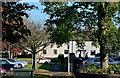
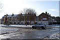
Pine Cross, Seymour Hill, Derriaghy (2)
See Image The opposite side of the street where the landscaping is, perhaps, even more obvious.
Image: © Albert Bridge
Taken: 27 Oct 2013
0.04 miles
3
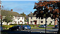
Pine Cross, Seymour Hill, Derriaghy (1)
When the Northern Ireland Housing Trust built the Seymour Hill estate it paid considerable attention to layout and landscaping much of which was the exact opposite of what would have been found in the narrow streets of terrace houses then common. The good design and the (now) mature trees are obvious, more than 50 years later, in this view of part of Pine Cross. Image shows the opposite side of the street.
Image: © Albert Bridge
Taken: 27 Oct 2013
0.05 miles
4
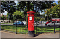
Pillar box, Seymour Hill, Dunmurry
EVIIR pillar box at Seymour Hill post office, Rowan Drive.
Image: © Albert Bridge
Taken: 24 Aug 2011
0.06 miles
6
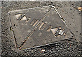
Arrol "Selflock" access cover, Seymour Hill, Derriaghy
An Arrol “Selflock” access cover at the Kingsway end of Rowan Drive, near the shops. It has a resemblance to this one Image and might have a connection with the former Dalmarnock Ironworks http://www.scotlandsplaces.gov.uk/record/rcahms/45147/glasgow-dunn-street-sir-william-arrols-works/rcahms.
Image: © Albert Bridge
Taken: 27 Oct 2013
0.11 miles
8
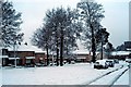
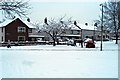
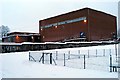
Larch Grove
A snowy view of Larch Grove and Oakland Way.
Image: © Wilson Adams
Taken: 4 Jan 2008
0.13 miles
10
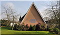
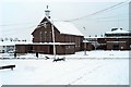
Kilmakee Presbyterian church, Derriaghy
Kilmakee Presbyterian Church opened in 1959 replacing a temporary wooden building. On the Ballybog Road, it mainly serves the Seymour Hill estate.
Image: © Albert Bridge
Taken: 23 Mar 2012
0.13 miles