IMAGES TAKEN NEAR TO
Elm Corner, BELFAST, BT17 9PY
Introduction
This page details the photographs taken nearby to Elm Corner, BT17 9PY by members of the Geograph project.
The Geograph project started in 2005 with the aim of publishing, organising and preserving representative images for every square kilometre of Great Britain, Ireland and the Isle of Man.

There are currently over 7.5m images from over14,400 individuals and you can help contribute to the project by visiting https://www.geograph.org.uk
Image Map
Images are licensed for reuse under creativecommons.org/licenses/by-sa/2.0
Notes
- Clicking on the map will re-center to the selected point.
- The higher the marker number, the further away the image location is from the centre of the postcode.
Image Listing (56 Images Found)
Images are licensed for reuse under creativecommons.org/licenses/by-sa/2.0
Image
Details
Distance
2
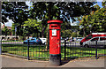
Pillar box, Seymour Hill, Dunmurry
EVIIR pillar box at Seymour Hill post office, Rowan Drive.
Image: © Albert Bridge
Taken: 24 Aug 2011
0.07 miles
3
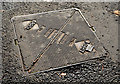
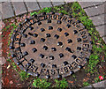
Arrol "Selflock" access cover, Seymour Hill, Derriaghy
An Arrol “Selflock” access cover at the Kingsway end of Rowan Drive, near the shops. It has a resemblance to this one Image and might have a connection with the former Dalmarnock Ironworks http://www.scotlandsplaces.gov.uk/record/rcahms/45147/glasgow-dunn-street-sir-william-arrols-works/rcahms.
Image: © Albert Bridge
Taken: 27 Oct 2013
0.08 miles
4
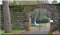
Gate and wall, Seymour Hill, Derriaghy
See Image This wall, at Yew Tree Walk, encloses the house’s former walled garden. Now known as the Seymour Hill Horticultural Unit it “supports over 40 adults with a learning disability and offers a broad range of training within a commercial garden centre. Clients are involved in the production of plants, retail outlet, landscaping and manufacturing hanging baskets, which are sold both to local businesses and the general public within the Dunmurry and Seymour Hill area”.
Image: © Albert Bridge
Taken: 24 Nov 2012
0.08 miles
5
Browns manhole cover, Seymour Hill, Dunmurry
One of the less-worn Browns manhole covers http://www.geograph.org.uk/search.php?i=24261515, at Laurel Way, Image , bearing the address of Sydney Street West, Belfast.
Image: © Albert Bridge
Taken: 24 Aug 2011
0.09 miles
6
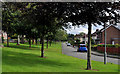
Laurel Way, Seymour Hill, Dunmurry
The Northern Ireland Housing Trust tended to put a bit more thought into its estates than the old councils. Laurel Way is well sheltered from Kingsway by several lines of trees. When work on the estate started, the M1 Image was still a dream. Kingsway was part of the main (only) road from Belfast to a large area from the road to Newry/Dublin west, to Omagh and Enniskillen.
Image: © Albert Bridge
Taken: 24 Aug 2011
0.09 miles
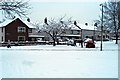
8
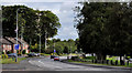
Kingsway, Seymour Hill, Dunmurry
Kingsway, part of the road from Black’s Road Image to Lambeg Image, passing Seymour Hill. Laurel Way Image is behind the trees on the right. The view is towards Finaghy. Image shows the view in the opposite direction.
Image: © Albert Bridge
Taken: 24 Aug 2011
0.10 miles
10
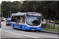
Bus, Seymour Hill, Dunmurry
An Ulsterbus Wright-bodied Scania passing along Kingsway Image with a service from the Europa Buscentre to Craigavon City Centre.
Image: © Albert Bridge
Taken: 24 Aug 2011
0.11 miles