IMAGES TAKEN NEAR TO
Aughrim Court, BELFAST, BT17 9PA
Introduction
This page details the photographs taken nearby to Aughrim Court, BT17 9PA by members of the Geograph project.
The Geograph project started in 2005 with the aim of publishing, organising and preserving representative images for every square kilometre of Great Britain, Ireland and the Isle of Man.

There are currently over 7.5m images from over14,400 individuals and you can help contribute to the project by visiting https://www.geograph.org.uk
Image Map
Images are licensed for reuse under creativecommons.org/licenses/by-sa/2.0
Notes
- Clicking on the map will re-center to the selected point.
- The higher the marker number, the further away the image location is from the centre of the postcode.
Image Listing (63 Images Found)
Images are licensed for reuse under creativecommons.org/licenses/by-sa/2.0
Image
Details
Distance
1
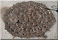
Brown's manhole cover, Derriaghy
A manhole cover, at Queensway (south eastern side), near the station. The cover is in excellent condition but is clogged with debris making the inscription (S BROWN & CO IRON FOUNDERS SYDNEY ST WEST BELFAST) difficult to read. See also Image
Image: © Albert Bridge
Taken: 7 Apr 2010
0.03 miles
2
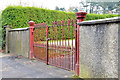
Ornamental gates, Derriaghy
Ornamental gates at Derriaghy orange hall, Queensway. Unlike here Image there is no maker’s name visible.
Image: © Albert Bridge
Taken: 24 Nov 2012
0.03 miles
3
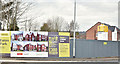
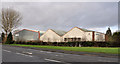
Eaton Park, Derriaghy (April 2016)
See Image Eaton Park is a development of houses and apartments, now under construction, on the opposite side of The Cutts.
Image: © Albert Bridge
Taken: 14 Apr 2016
0.04 miles
4
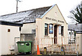
Bethany Church of the Nazarene, Derriaghy
On a cramped site between Killeaton Crescent and The Cutts. Originally the Derriaghy Mission Hall (thought to have been built in the early part of the 20th century) the present church has occupied the building since 1995. I have included it in the “Gospel Hall” shared description since it is a former mission hall.
Image: © Albert Bridge
Taken: 24 Nov 2012
0.04 miles
5
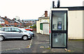
Telephone box, Derriaghy
Telephone box, at the corner of Killeaton Crescent (background) and Queensway, close to Image Today was the first real frost of the 2012/13 winter. The box looks a bit misty as the frost starts to thaw.
Image: © Albert Bridge
Taken: 24 Nov 2012
0.05 miles
6
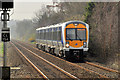
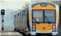
Train, Derriaghy (2012-1)
A C3K set (3008) approaching Derriaghy station with the 11.15 Portadown - Bangor. The last of the lingering mist can be seen in the background, towards Lambeg.
Image: © Albert Bridge
Taken: 23 Mar 2012
0.06 miles
7
Eaton Court, Derriaghy (3)
Image: © Albert Bridge
Taken: 27 Oct 2013
0.06 miles
8
Aberdelghy golf course, Derriaghy
Aberdelghy golf course Image stretches from Lambeg to Derriaghy. This is the northern end near Conway Lane.
Image: © Albert Bridge
Taken: 28 May 2011
0.06 miles
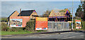
9
Vacant warehouses, Derriaghy (2)
See Image The Queensway Image end of the site (on the right in the previous photograph). Note added 12 June 2012 – now demolished.
Image shows the new houses under construction in November 2012.
Image: © Albert Bridge
Taken: 7 Jan 2012
0.07 miles
10
Signal, Derriaghy station
A colour light signal, at the Lisburn end of the up platform at Derriaghy station, displaying a green (line clear) aspect on the approach of the 10.57 Bangor – Portadown.
Image: © Albert Bridge
Taken: 24 Nov 2012
0.07 miles