IMAGES TAKEN NEAR TO
Ashley Grove, BELFAST, BT17 9EA
Introduction
This page details the photographs taken nearby to Ashley Grove, BT17 9EA by members of the Geograph project.
The Geograph project started in 2005 with the aim of publishing, organising and preserving representative images for every square kilometre of Great Britain, Ireland and the Isle of Man.

There are currently over 7.5m images from over14,400 individuals and you can help contribute to the project by visiting https://www.geograph.org.uk
Image Map
Images are licensed for reuse under creativecommons.org/licenses/by-sa/2.0
Notes
- Clicking on the map will re-center to the selected point.
- The higher the marker number, the further away the image location is from the centre of the postcode.
Image Listing (45 Images Found)
Images are licensed for reuse under creativecommons.org/licenses/by-sa/2.0
Image
Details
Distance
1
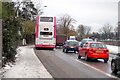
Gridlocked Traffic
This is a common occurrence for those travelling towards Dunmurry/Belfast every weekday (Mon to Fri). Only the bus has its own lane to speed up journeys to Belfast.
Image: © Wilson Adams
Taken: 25 Nov 2005
0.10 miles
2
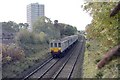
Thornhill Rd, Dunmurry
A local train heading for Lisburn. For a view of the bridge where I made this photo, Image
Image: © Wilson Adams
Taken: 15 Oct 2004
0.10 miles

4

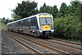
Enterprise passing Seymour Hill
The 15:20 Dublin to Belfast Enterprise passing Seymour Hill.
To the right of the photo, is the old De Loren car manufacturing plant.
Image: © Wilson Adams
Taken: 15 Apr 2006
0.10 miles
5
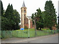
Dunmurry Presbyterian Church
An Italianate design from the nineteenth century.
Image: © Brian Shaw
Taken: 21 Sep 2005
0.10 miles
6
A passing train
Nothing of interest in this photo except for 3023 working a 12:00pm Portadown to Bangor local service, passing Kingsway. Thornhill Rd is to the left and Meetinghouse Crossing to the right of the photographer. Behind the hedge is Richardson's Park Football Ground.
Image: © Wilson Adams
Taken: 17 Jun 2007
0.11 miles
7
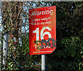
Weight restriction sign, Dunmurry
Image: © Albert Bridge
Taken: 7 Apr 2010
0.13 miles
8
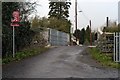
Railway Bridge
Railway bridge that carries the Thornhill Rd over the Belfast to Dublin mainline. An unusual fact about this bridge is, it's only rated to carry 16 Tons across the span. It may well have something to do with the fact that the centre span was constructed using old 60 foot flat-bottom rails, cased in concrete, instead of the usual construction of reinforced concrete.
Image: © Wilson Adams
Taken: 18 Mar 2007
0.13 miles
9
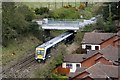
A railway bridge
A railway bridge at Thornhill Road, Dunmurry. It is impossible to make a lineside photo of the bridge, due to the railway being built on an embankment and also heavily overgrown with bushes/trees etc. The milepost on the lefthand side reads 108, this is the distance from Amiens Street, Dublin, and it is another 4.5 miles to go before reaching Belfast. The train in the photo is travelling from Belfast (right) to Lisburn (left). This image was made from the 12th floor multi-storey block of flats at Seymour Hill. The houses to the bottom right of the photo, have been constructed within the last 5 years. Previously this area was farmland.
Image: © Wilson Adams
Taken: 15 Apr 2006
0.13 miles
10
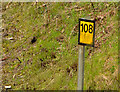
Railway milepost, Derriaghy
Milepost 108 (from Dublin Connolly) on the Derriaghy side of the Thornhill Road bridge Image
Image: © Albert Bridge
Taken: 12 Apr 2014
0.13 miles