IMAGES TAKEN NEAR TO
Glenburn Court, BELFAST, BT17 9BS
Introduction
This page details the photographs taken nearby to Glenburn Court, BT17 9BS by members of the Geograph project.
The Geograph project started in 2005 with the aim of publishing, organising and preserving representative images for every square kilometre of Great Britain, Ireland and the Isle of Man.

There are currently over 7.5m images from over14,400 individuals and you can help contribute to the project by visiting https://www.geograph.org.uk
Image Map
Images are licensed for reuse under creativecommons.org/licenses/by-sa/2.0
Notes
- Clicking on the map will re-center to the selected point.
- The higher the marker number, the further away the image location is from the centre of the postcode.
Image Listing (87 Images Found)
Images are licensed for reuse under creativecommons.org/licenses/by-sa/2.0
Image
Details
Distance
1
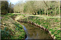
The Derryaghy River, Dunmurry
The short Derryaghy River (looking upstream) flowing through Derryaghy Linear Park, near Seymour Hill.
Image: © Albert Bridge
Taken: 7 Apr 2010
0.04 miles
2
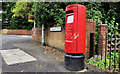
Pillar box, Dunmurry
EIIR pillar box, on the Glenburn Road, close to Glenburn Court.
Image: © Albert Bridge
Taken: 6 Aug 2011
0.04 miles
3
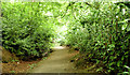
Wooded path, Derriaghy (July 2014)
A wooded path, partly lined with laurel bushes, on the south western side of the Derryaghy River, to the north of Yew Tree Walk.
Image: © Albert Bridge
Taken: 19 Jul 2014
0.06 miles
4
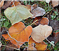
Frosty leaves, Seymour Hill, Derriaghy
Today was the first real frost of the 2012/13 winter. It lingered until almost noon. These frosty leaves were on a large area of undisturbed grass at Yew Tree Walk, close to here Image Another member has suggested that these unusually-shaped leaves might be from a tulip tree http://en.wikipedia.org/wiki/Liriodendron.
Image: © Albert Bridge
Taken: 24 Nov 2012
0.09 miles
5
Frosty grass, Seymour Hill, Derriaghy
Today was the first real frost of the 2012/13 winter. It lingered until almost noon. This scene is at Yew Tree Walk, looking towards the Derryaghy River Image (below the trees in the background).
Image: © Albert Bridge
Taken: 24 Nov 2012
0.09 miles
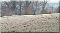
6
Old Forge, Dunmurry (April 2014)
Work on this housing association group of houses and apartments, at Kingsway (now named “Old Forge”), seems to be close to completion. So far, they don’t seem to be occupied.
Image: © Albert Bridge
Taken: 12 Apr 2014
0.09 miles
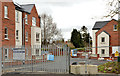
7
New social housing, Dunmurry (2)
See Image (November 2012). A similar view some eleven months later. Image shows the almost complete block on the left.
Image: © Albert Bridge
Taken: 27 Oct 2013
0.09 miles
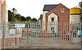
8
Dunmurry gospel hall
See Image The same hall – four years later.
Image: © Albert Bridge
Taken: 6 Aug 2011
0.09 miles
9
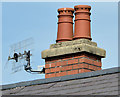
Dunmurry Primary School (2)
See Image A chimney with two well-preserved and possibly original pots decorated by top holes.
Image: © Albert Bridge
Taken: 19 Apr 2014
0.10 miles
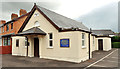
10
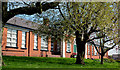
Dunmurry Primary School (1)
A primary school on the Glenburn Road. Not listed but mention there as “This building was surveyed in the First Survey but not listed. Partial record only was taken during the Second Survey as the building is not worthy of a full survey. A red-brick single-storey school with breakfront entrance bay built c.1930 and situated south [sic] of Glenburn Road in Dunmurry. The building has been altered and refurbished over the years”. Image shows the chimney.
Image: © Albert Bridge
Taken: 19 Apr 2014
0.10 miles