IMAGES TAKEN NEAR TO
Grange Hill, Kingsway, BELFAST, BT17 9AW
Introduction
This page details the photographs taken nearby to Grange Hill, Kingsway, BT17 9AW by members of the Geograph project.
The Geograph project started in 2005 with the aim of publishing, organising and preserving representative images for every square kilometre of Great Britain, Ireland and the Isle of Man.

There are currently over 7.5m images from over14,400 individuals and you can help contribute to the project by visiting https://www.geograph.org.uk
Image Map
Images are licensed for reuse under creativecommons.org/licenses/by-sa/2.0
Notes
- Clicking on the map will re-center to the selected point.
- The higher the marker number, the further away the image location is from the centre of the postcode.
Image Listing (85 Images Found)
Images are licensed for reuse under creativecommons.org/licenses/by-sa/2.0
Image
Details
Distance
1
Bardan Cottage, Dunmurry - December 2014(2)
See Image A self-explanatory sign facing Kingsway.
Image: © Albert Bridge
Taken: 20 Dec 2014
0.03 miles
2
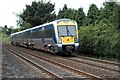
A passing train
Nothing of interest in this photo except for 3023 working a 12:00pm Portadown to Bangor local service, passing Kingsway. Thornhill Rd is to the left and Meetinghouse Crossing to the right of the photographer. Behind the hedge is Richardson's Park Football Ground.
Image: © Wilson Adams
Taken: 17 Jun 2007
0.03 miles
3
RFD Dunmurry
The RFD (Rafts, Floats & Dinghies) Factory est: between 1950 & 1960.
Previously, this factory was owned by the N.I.R.T.B. and U.T.A. transport companies, producing buses for the respective companies.
Image: © Wilson Adams
Taken: 3 Mar 2007
0.04 miles
4
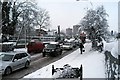
Kingsway, Dunmurry
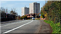
Traffic chaos at Kingsway. The RFD factory on the left, and Seymour Hill flats mid image. The Belfast to Dublin railway line is to the right of the image, out of view.
Image: © Wilson Adams
Taken: 4 Jan 2008
0.05 miles
5
Bardan Cottage, Dunmurry - December 2014(1)
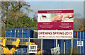
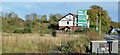
Bardan Cottage – a day care centre http://bardancottage.com/bardan-cottage-dunmurry/ now under construction here Image (October 2013) at Kingsway. The site was advertised with a lapsed planning permission for apartments. The following now applies: “S/2014/0184/F Lands formerly known as 265/267 Kingsway (immediately SW of 1-4 Grange Hall) Kingsway Dunmurry Proposed Daycare Centre for the Elderly and associated site works 01/09/2014”. The Thornhill Road is on the left. This photograph appears as a matter of record only. I have no connection with anyone involved in the construction or operation of the centre. Continue to Image
Image: © Albert Bridge
Taken: 20 Dec 2014
0.05 miles
6
Development site, Dunmurry/Derriaghy
Part of a site at 265/267 Kingsway (corner of the Thornhill Road) offered for sale and described by the agents as “The subject site is approximately 0.48 acres with main road frontage. The most recent planning application on the site (S/2006/0979/F) was passed on 18th December 2007 for 18 apartments. Although this application has since elapsed [sic], it shows the potential of the site for residential development”. This photograph appears as a matter of record only. I have no connection with any of the parties involved in the sale. Continue to Image
Image: © Albert Bridge
Taken: 27 Oct 2013
0.05 miles
7
Kingsway, Dunmurry
See Image The same road, at a quieter time of day and looking towards Lisburn, as it passes the RFD Beaufort factory Image
Image: © Albert Bridge
Taken: 7 Apr 2010
0.05 miles
8
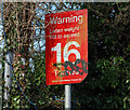
Weight restriction sign, Dunmurry
Image: © Albert Bridge
Taken: 7 Apr 2010
0.05 miles
9
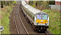
The "Enterprise", Derriaghy (April 2014)
The 10.35 Dublin – Belfast “Enterprise” (9001/209) approaching the Thornhill Road bridge Image The Meeting House crossing Image is at middle top.
Image: © Albert Bridge
Taken: 12 Apr 2014
0.06 miles
10
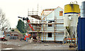
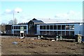
New social housing, Dunmurry
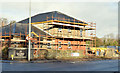
New housing association houses and flats under construction, on the site of the former “Castrol” warehouse, at Kingsway.
Image: © Albert Bridge
Taken: 24 Nov 2012
0.06 miles