IMAGES TAKEN NEAR TO
Kingsway, BELFAST, BT17 9AF
Introduction
This page details the photographs taken nearby to Kingsway, BT17 9AF by members of the Geograph project.
The Geograph project started in 2005 with the aim of publishing, organising and preserving representative images for every square kilometre of Great Britain, Ireland and the Isle of Man.

There are currently over 7.5m images from over14,400 individuals and you can help contribute to the project by visiting https://www.geograph.org.uk
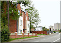
Image Map
Images are licensed for reuse under creativecommons.org/licenses/by-sa/2.0
Notes
- Clicking on the map will re-center to the selected point.
- The higher the marker number, the further away the image location is from the centre of the postcode.
Image Listing (89 Images Found)
Images are licensed for reuse under creativecommons.org/licenses/by-sa/2.0
Image
Details
Distance
1
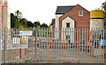
New social housing, Dunmurry (2)
See Image (November 2012). A similar view some eleven months later. Image shows the almost complete block on the left.
Image: © Albert Bridge
Taken: 27 Oct 2013
0.04 miles
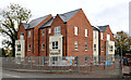
2
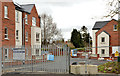
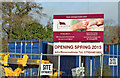
Old Forge, Dunmurry (April 2014)
Work on this housing association group of houses and apartments, at Kingsway (now named “Old Forge”), seems to be close to completion. So far, they don’t seem to be occupied.
Image: © Albert Bridge
Taken: 12 Apr 2014
0.04 miles
3
Vacant warehouse, Dunmurry
A long-vacant warehouse, beside Image at Kingsway, once occupied by Castrol.
Image: © Albert Bridge
Taken: 24 Aug 2011
0.04 miles
4
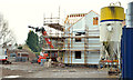
New social housing, Dunmurry
New housing association houses and flats under construction, on the site of the former “Castrol” warehouse, at Kingsway.
Image: © Albert Bridge
Taken: 24 Nov 2012
0.04 miles
5
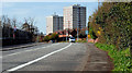
Kingsway, Dunmurry
See Image The same road, at a quieter time of day and looking towards Lisburn, as it passes the RFD Beaufort factory Image
Image: © Albert Bridge
Taken: 7 Apr 2010
0.06 miles
6
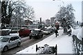
Kingsway, Dunmurry
Traffic chaos at Kingsway. The RFD factory on the left, and Seymour Hill flats mid image. The Belfast to Dublin railway line is to the right of the image, out of view.
Image: © Wilson Adams
Taken: 4 Jan 2008
0.06 miles
7
RFD Dunmurry
The RFD (Rafts, Floats & Dinghies) Factory est: between 1950 & 1960.
Previously, this factory was owned by the N.I.R.T.B. and U.T.A. transport companies, producing buses for the respective companies.
Image: © Wilson Adams
Taken: 3 Mar 2007
0.06 miles
8
Bardan Cottage, Dunmurry - December 2014(2)
See Image A self-explanatory sign facing Kingsway.
Image: © Albert Bridge
Taken: 20 Dec 2014
0.06 miles
9
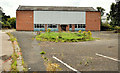
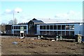
Old Forge, Dunmurry (July 2014)
For the record – the completed houses and apartments looking towards Seymour Hill. “Old Forge” is a townland once called “Ballydolleghan”.
Image: © Albert Bridge
Taken: 19 Jul 2014
0.07 miles
10
New social housing, Dunmurry (3)
The block of apartments, on the left, in Image Kingsway is in the foreground.
Image: © Albert Bridge
Taken: 27 Oct 2013
0.07 miles