IMAGES TAKEN NEAR TO
Alina Gardens, BELFAST, BT17 0QJ
Introduction
This page details the photographs taken nearby to Alina Gardens, BT17 0QJ by members of the Geograph project.
The Geograph project started in 2005 with the aim of publishing, organising and preserving representative images for every square kilometre of Great Britain, Ireland and the Isle of Man.

There are currently over 7.5m images from over14,400 individuals and you can help contribute to the project by visiting https://www.geograph.org.uk
Image Map
Images are licensed for reuse under creativecommons.org/licenses/by-sa/2.0
Notes
- Clicking on the map will re-center to the selected point.
- The higher the marker number, the further away the image location is from the centre of the postcode.
Image Listing (3 Images Found)
Images are licensed for reuse under creativecommons.org/licenses/by-sa/2.0
Image
Details
Distance
1
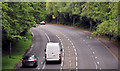
Creighton Road, Dunmurry (1)
Part of the Dunmurry bypass, Creighton Road runs from the McKinstry Road, Lambeg/Derriaghy Image to the Old Golf Course Road, Dunmurry Image This view is towards Lambeg, from the flyover on Upper Dunmurry Lane.
Image: © Albert Bridge
Taken: 1 Aug 2011
0.19 miles
2
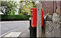
Letter box, Dunmurry
Post-mounted EIIR letter box at the corner of Areema Drive and Upper Dunmurry Lane (background).
Image: © Albert Bridge
Taken: 1 Aug 2011
0.20 miles
3
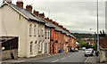
Maryville Terrace, Dunmurry
A terrace of traditional redbrick houses, some of which are now rendered, on the northern side of Upper Dunmurry Lane.
Image: © Albert Bridge
Taken: 1 Aug 2011
0.25 miles