IMAGES TAKEN NEAR TO
Upper Springfield Road, BELFAST, BT17 0NB
Introduction
This page details the photographs taken nearby to Upper Springfield Road, BT17 0NB by members of the Geograph project.
The Geograph project started in 2005 with the aim of publishing, organising and preserving representative images for every square kilometre of Great Britain, Ireland and the Isle of Man.

There are currently over 7.5m images from over14,400 individuals and you can help contribute to the project by visiting https://www.geograph.org.uk
Image Map
Images are licensed for reuse under creativecommons.org/licenses/by-sa/2.0
Notes
- Clicking on the map will re-center to the selected point.
- The higher the marker number, the further away the image location is from the centre of the postcode.
Image Listing (6 Images Found)
Images are licensed for reuse under creativecommons.org/licenses/by-sa/2.0
Image
Details
Distance
1
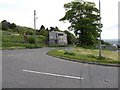
The junction of Hannahstown Hill with the B38 (Upper Springfield Road)
Image: © Eric Jones
Taken: 19 May 2012
0.13 miles
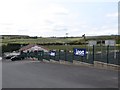
2
Pairc Lamh Dhearg (Red Hand Park) GAA Club, Upper Springfield Road
http://en.wikipedia.org/wiki/L%C3%A1mh_Dhearg_GAC
Image: © Eric Jones
Taken: 19 May 2012
0.17 miles
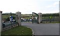
3
The Club House at Pairc Lamh Dhearg (Red Hand Park) GAA Club
http://en.wikipedia.org/wiki/L%C3%A1mh_Dhearg_GAC
Image: © Eric Jones
Taken: 19 May 2012
0.19 miles
4
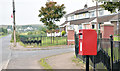
Pressed-steel postbox (BT17 923), Hannahstown, Belfast (August 2016)
Post-mounted pressed-steel EIIR postbox (BT17 923) beside the Upper Springfield Road.
Image: © Albert Bridge
Taken: 18 Aug 2016
0.20 miles
5
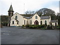
St. Joseph's Hannahstown
The leftmost nave of this Catholic Church was built in 1826. The other two were added in 1998. It's lovely inside, with the three naves pointing towards the altar.
Image: © Brian Shaw
Taken: 19 Dec 2005
0.20 miles
6
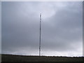
Black Mountain Transmitter Mast.
Situated at Hannahstown, West Belfast.
Image: © Peter Lyons
Taken: Unknown
0.20 miles