IMAGES TAKEN NEAR TO
Colin Glen Green, BELFAST, BT17 0HX
Introduction
This page details the photographs taken nearby to Colin Glen Green, BT17 0HX by members of the Geograph project.
The Geograph project started in 2005 with the aim of publishing, organising and preserving representative images for every square kilometre of Great Britain, Ireland and the Isle of Man.

There are currently over 7.5m images from over14,400 individuals and you can help contribute to the project by visiting https://www.geograph.org.uk
Image Map
Images are licensed for reuse under creativecommons.org/licenses/by-sa/2.0
Notes
- Clicking on the map will re-center to the selected point.
- The higher the marker number, the further away the image location is from the centre of the postcode.
Image Listing (7 Images Found)
Images are licensed for reuse under creativecommons.org/licenses/by-sa/2.0
Image
Details
Distance
1
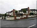
Hawthorn Glen
Or Gleann na Sceiche in the vernacular - modern housing off Shaw's Road, Belfast.
Image: © Brian Shaw
Taken: 19 Dec 2005
0.03 miles
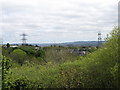
4
View across the wooded Colin Glen towards Hannahstown
Hannahstown is a pleasant suburb on the slopes of the Belfast Mountains.
Image: © Eric Jones
Taken: 19 May 2012
0.10 miles
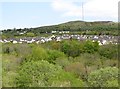
5
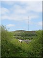
Modern estate in Hannahstown viewed from the Colin Glen Park
In the background is a white limestone quarry and the Divis telecommunications mast.
Image: © Eric Jones
Taken: 19 May 2012
0.13 miles
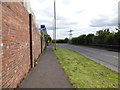
6
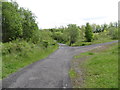
Trail junction at Colin Glen Forest Park
Image: © Eric Jones
Taken: 19 May 2012
0.17 miles
7
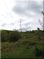
Powerlines crossing a former quarry on the edge of Colin Glen
Image: © Eric Jones
Taken: 19 May 2012
0.24 miles