IMAGES TAKEN NEAR TO
Cloona Park, BELFAST, BT17 0HH
Introduction
This page details the photographs taken nearby to Cloona Park, BT17 0HH by members of the Geograph project.
The Geograph project started in 2005 with the aim of publishing, organising and preserving representative images for every square kilometre of Great Britain, Ireland and the Isle of Man.

There are currently over 7.5m images from over14,400 individuals and you can help contribute to the project by visiting https://www.geograph.org.uk
Image Map
Images are licensed for reuse under creativecommons.org/licenses/by-sa/2.0
Notes
- Clicking on the map will re-center to the selected point.
- The higher the marker number, the further away the image location is from the centre of the postcode.
Image Listing (5 Images Found)
Images are licensed for reuse under creativecommons.org/licenses/by-sa/2.0
Image
Details
Distance
1
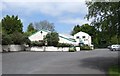
Visitors Centre at the Colin Glen Forest Park
The Colin Glen Forest Park comprises of some 200 acres of scenic woodland, river, open grassland, waterfalls and wild flower areas along the banks of the incised Colin River where it descends from the Belfast Mountains. .
http://www.colinglentrust.org/
Image: © Eric Jones
Taken: 19 May 2012
0.20 miles
3
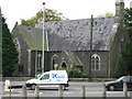
St John the Baptist, Upper Falls
This Church of Ireland Parish Church was consecrated in 1861.
Image: © Brian Shaw
Taken: 18 Oct 2005
0.21 miles
4
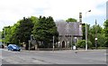
St John the Baptist (CoI)
This church stands at the junction of Andersonstown Road and Suffolk Road. The church is on the edge of the Colin Glen Forest Park.
Image: © Eric Jones
Taken: 19 May 2012
0.24 miles
5
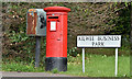
Pillar box BT17 50, Dunmurry (April 2017)
EIIR pillar box (BT17 50) beside a rusty drop box, at the entrance to Kilwee Business Park, Upper Dunmurry Lane.
Image: © Albert Bridge
Taken: 29 Apr 2017
0.24 miles