IMAGES TAKEN NEAR TO
Railway Street, BELFAST, BT17 0AQ

Introduction

This page details the photographs taken nearby to Railway Street, BT17 0AQ by members of the Geograph project.

The Geograph project started in 2005 with the aim of publishing, organising and preserving representative images for every square kilometre of Great Britain, Ireland and the Isle of Man.

There are currently over 7.5m images from over14,400 individuals and you can help contribute to the project by visiting https://www.geograph.org.uk

Image Map


Images are licensed for reuse under creativecommons.org/licenses/by-sa/2.0
Notes
  • Clicking on the map will re-center to the selected point.
  • The higher the marker number, the further away the image location is from the centre of the postcode.

Image Listing (142 Images Found)

Images are licensed for reuse under creativecommons.org/licenses/by-sa/2.0
  • ...
Image
Details
Distance
1
Railway Street, Dunmurry
Short street of terraced houses. The Belfast - Lisburn railway line lies behind the houses on the right. See also Image and Image
Image: © Rossographer Taken: 22 Mar 2011
0.02 miles
2
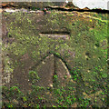
Bench Mark, Dunmurry
Cut bench mark on the left hand side of the Railway Bridge seen in Image The mark is 25.35 metres above MSL. See also http://www.geograph.org.uk/search.php?i=11037856 for many other examples I have found.
Image: © Rossographer Taken: 22 Mar 2011
0.03 miles
3
GPO access cover, Dunmurry
Detail of an access cover for telephone cables located on Railway Street, Dunmurry. Marked "GPO" (General Post Office), these are still relatively common, although this example uses a type face I have not seen before and appears to be older than most. If anyone knows what the letters and numbers refer to I'd love to know.
Image: © Rossographer Taken: 22 Mar 2011
0.03 miles
4
Level crossing, Dunmurry (3)
See Image The crossing keeper’s hut (right) on the Belfast side of the level crossing beside the up line. Dunmurry station can be seen (background) to the left of the hut. Continue to Image
Image: © Albert Bridge Taken: 17 Feb 2009
0.04 miles
5
Railway bridge, Dunmurry (1)
The north western side of the bridge, looking towards Dunmurry. The entrance to the station is out of picture to the left. Continue to Image
Image: © Albert Bridge Taken: 7 Apr 2010
0.04 miles
6
Railway bridge, Dunmurry (2)
See Image The Dunmurry side of the bridge with the entrance to the station out of picture on the right. Continue to Image
Image: © Albert Bridge Taken: 7 Apr 2010
0.04 miles
7
Railway bridge, Dunmurry (3)
See Image The pedestrian arch with the entrance to the station out of picture on the right. Continue to Image
Image: © Albert Bridge Taken: 28 Oct 2009
0.04 miles
8
Railway bridge, Dunmurry (4)
See Image The bridge-strike sign on the Dunmurry side. Continue to Image
Image: © Albert Bridge Taken: 7 Apr 2010
0.04 miles
9
Railway bridge, Dunmurry (5)
See Image The height-restriction signs on the Dunmurry side.
Image: © Albert Bridge Taken: 7 Apr 2010
0.04 miles
10
Dunmurry Station
The entrance to the UP platform at Dunmurry Station. (UP to Dublin, Down to Belfast).
Image: © Wilson Adams Taken: 22 Sep 2007
0.04 miles
  • ...