IMAGES TAKEN NEAR TO
Hill Street, BELFAST, BT17 0AD
Introduction
This page details the photographs taken nearby to Hill Street, BT17 0AD by members of the Geograph project.
The Geograph project started in 2005 with the aim of publishing, organising and preserving representative images for every square kilometre of Great Britain, Ireland and the Isle of Man.

There are currently over 7.5m images from over14,400 individuals and you can help contribute to the project by visiting https://www.geograph.org.uk
Image Map
Images are licensed for reuse under creativecommons.org/licenses/by-sa/2.0
Notes
- Clicking on the map will re-center to the selected point.
- The higher the marker number, the further away the image location is from the centre of the postcode.
Image Listing (152 Images Found)
Images are licensed for reuse under creativecommons.org/licenses/by-sa/2.0
Image
Details
Distance
1
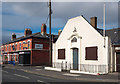
Dunmurry Orange Hall
Dunmurry Orange Hall on Upper Dunmurry Lane. Previously seen in Image The hall opened in 1908.
Image: © Rossographer
Taken: 22 Mar 2011
0.02 miles
2
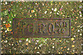
GPO access cover, Dunmurry
Detail of an access cover for telephone cables located on Railway Street, Dunmurry. Marked "GPO" (General Post Office), these are still relatively common, although this example uses a type face I have not seen before and appears to be older than most. If anyone knows what the letters and numbers refer to I'd love to know.
Image: © Rossographer
Taken: 22 Mar 2011
0.05 miles
3
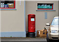
Pillar box, Dunmurry
EIIR pillar box at Kingsway, outside the post office Image Image shows the same box, in its new position, after the post office closed.
Image: © Albert Bridge
Taken: 1 Aug 2011
0.05 miles
4
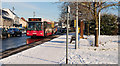
Conway bus, Dunmurry
An Alexander (Belfast) bodied Volvo, passing along Kingsway, with the 11.38 Donegall Square East – Conway estate Metro service no 9A - exactly on time.
Image: © Albert Bridge
Taken: 7 Dec 2010
0.06 miles
5
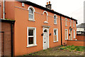
Roselea Cottages, Dunmurry (2012-1)
Two vacant houses at nos 3&5 Dunmurry Lane – offered for sale and included in this lot Image Last seen, when occupied, in March 2007 Image Image shows the name sign. This photograph appears as a matter of record only. I have no connection with any of the parties involved in the sale.
Continue to Image (July 2013).
Image: © Albert Bridge
Taken: 9 Mar 2012
0.06 miles
6
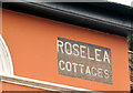
Roselea Cottages, Dunmurry (2012-2)
The name sign at the crossroads end of Roselea Cottages Image, Dunmurry Lane.
Image: © Albert Bridge
Taken: 9 Mar 2012
0.06 miles
7
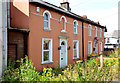
Roselea Cottages, Dunmurry (2013)
See Image (March 2012). The vacant houses remain undeveloped.
Image: © Albert Bridge
Taken: 17 Jul 2013
0.06 miles
8
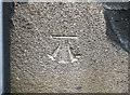
Bench Mark, Dunmurry
Cut bench mark on the western side of a church hall on Kingsway, Dunmurry.
The mark is 26.36 metres above MSL.
See also http://www.geograph.org.uk/search.php?i=11037856 for many other examples I have found.
Image: © Rossographer
Taken: 21 Apr 2010
0.06 miles
9
Train, Dunmurry station (4)
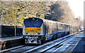
See Image The 09.35 Dublin – Belfast “Enterprise” passing Dunmurry, just over 30 minutes late, for the same reason “Delays can be expected on the Bangor/Portadown Line due to signalling problems being experienced between Belfast Central and Lisburn.” The train is worked on the push-pull principle with the locomotive (228 in this case) at the Belfast end. The driving trailer in 9001.
Image: © Albert Bridge
Taken: 7 Dec 2010
0.07 miles
10
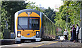
Train, Dunmurry station 2013#3
C3K set no 3019 arriving at Dunmurry with the 10.15 Portadown – Bangor.
Image: © Albert Bridge
Taken: 31 Aug 2013
0.07 miles