IMAGES TAKEN NEAR TO
Howard Street, BELFAST, BT1 6PA
Introduction
This page details the photographs taken nearby to Howard Street, BT1 6PA by members of the Geograph project.
The Geograph project started in 2005 with the aim of publishing, organising and preserving representative images for every square kilometre of Great Britain, Ireland and the Isle of Man.

There are currently over 7.5m images from over14,400 individuals and you can help contribute to the project by visiting https://www.geograph.org.uk
Image Map
Images are licensed for reuse under creativecommons.org/licenses/by-sa/2.0
Notes
- Clicking on the map will re-center to the selected point.
- The higher the marker number, the further away the image location is from the centre of the postcode.
Image Listing (3124 Images Found)
Images are licensed for reuse under creativecommons.org/licenses/by-sa/2.0
Image
Details
Distance
1
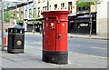
Postbox BT2 5, Belfast (June 2015)
See Image This dual aperture EIIR postbox (BT2 5) is a recent installation outside the replacement post office at Howard Street. The two Bedford Street boxes remain.
Image: © Albert Bridge
Taken: 21 Jun 2015
0.01 miles
2
Howard Buildings, Belfast (June 2017)
An early stage of work to convert the building to a hotel. The only thing visible is a contractor’s sign showing that internal clearance has started.
Image: © Albert Bridge
Taken: 30 Jun 2017
0.01 miles
3
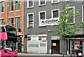
"To let" shop, Belfast (10)
A vacant shop to let at 16 Howard Street. See also Image (April 2014).
Image: © Albert Bridge
Taken: 13 May 2012
0.01 miles
4
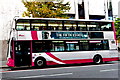
Belfast - City Centre - Double-Decker Bus on Howard Street
Location is in front of Northern Bank building just west of the intersection of Howard Street with Donegall Square W to the north and Bedford Street to the south. View is to the northeast from the south side of Howard Street.
Image: © Suzanne Mischyshyn
Taken: 23 Sep 2013
0.01 miles
5
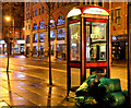
Nocturnal telephone box, Belfast
A BT telephone box, in Howard Street, accompanied by some commercial refuse awaiting collection.
Image: © Albert Bridge
Taken: 17 Feb 2014
0.01 miles
6
Howard Street
Looking west to Upper Queen Street.
Image: © Thomas Nugent
Taken: 1 Jun 2019
0.02 miles
7

Demolition, Howard Street, Belfast
Demolition of nos 20&22 Howard Street to make way for new offices and shops. Image shows the replacement building.
Image: © Albert Bridge
Taken: 15 Oct 1982
0.02 miles
8
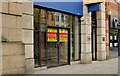
Nos 20 and 22 Howard Street, Belfast
See Image The previous photo showed the demolition of nos 20 and 22 Howard Street. The red-brick building is the replacement.
Image: © Albert Bridge
Taken: 19 Jul 2009
0.02 miles
9
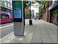
InLink kiosk, Howard Street, Belfast (February 2019)
The shape of future public telecommunications now erected at Howard Street, on a site once occupied by an “Inter-Phone” box Image
“Good-Bye Payphone, Hello InLink! InLinkUK is a new communications service that will replace over 1,000 payphones in major cities across the UK, with new structures called InLinks. Each InLink provides ultrafast, free public Wi-Fi, phone calls, device charging and a tablet for access to city services, maps and directions” - BT website.
There have been numerous applications for planning permission. In this case approved on 11 September 2018 “LA04/2018/0885/F 1No. InLink kiosk Donegall Square outside Dankse Bank junction with Howard Street Belfast BT1 6JS”.
Image: © Albert Bridge
Taken: 16 Feb 2019
0.02 miles
10
Head office, Northern Bank, Belfast
The head office of the Northern Bank in Donegall Square West, between Howard Street (left) and Wellington Street (right) was built over a number of years in the early seventies. The unfortunate thing was that its predecessor (a cousin of St Pancras station) had to be demolished. See also Image
Image: © Albert Bridge
Taken: 2 Mar 2008
0.02 miles