IMAGES TAKEN NEAR TO
Upper Queen Street, BELFAST, BT1 6FB
Introduction
This page details the photographs taken nearby to Upper Queen Street, BT1 6FB by members of the Geograph project.
The Geograph project started in 2005 with the aim of publishing, organising and preserving representative images for every square kilometre of Great Britain, Ireland and the Isle of Man.

There are currently over 7.5m images from over14,400 individuals and you can help contribute to the project by visiting https://www.geograph.org.uk
Image Map
Images are licensed for reuse under creativecommons.org/licenses/by-sa/2.0
Notes
- Clicking on the map will re-center to the selected point.
- The higher the marker number, the further away the image location is from the centre of the postcode.
Image Listing (3016 Images Found)
Images are licensed for reuse under creativecommons.org/licenses/by-sa/2.0
Image
Details
Distance
1
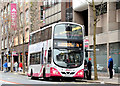
Boxing Day bus, Belfast (2014)
There were no trains today but Ulsterbus and Metro operated a limited service on some routes. A Metro Wright-bodied Volvo (2344 - SEZ 2344) is awaiting departure from Upper Queen Street for Monkstown via Rathcoole (2E). The service was hourly. The usual frequency is every eleven minutes.
Image: © Albert Bridge
Taken: 26 Dec 2014
0.00 miles
2
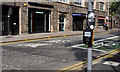
Upper Queen Street, Belfast (2)
The proposal to remove most (if not all) Metro buses from Donegall Square/the City Hall has been discussed over a long number of years. The first steps were taken this week with the conversion of Upper Queen Street to a bus-priority street. It remains open to two-way traffic but now has a bus lane (7am-7pm) from Howard Street and new traffic lights at the crossroads with Howard Street Image and Brunswick Street Image Image shows the old arrangement.
Image: © Albert Bridge
Taken: 4 Sep 2011
0.01 miles
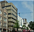
3

Former Eagle Star House, Belfast
An office black, in Upper Queen Street, built (I think) in the late 1970’s for the Eagle Star (later the Zurich Insurance Group). The latter has now moved to other premises. The building is unusual in that the lift did not serve the top floor.
Image: © Albert Bridge
Taken: 27 Jan 2013
0.01 miles
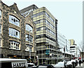
4
Eagle Star House, Belfast - June 2018(1)
Eagle Star House from Upper Queen Street. Buses tend to obscure the view.
Image: © Albert Bridge
Taken: 2 Jun 2018
0.01 miles
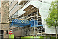
5
Eagle Star House, Belfast - March 2019(1)
Erecting scaffolding at Upper Queen Street.
Image: © Albert Bridge
Taken: 11 Mar 2019
0.01 miles
6
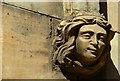
Former Church House, Belfast (10)
See Image This head is on the Upper Queen Street façade.
Image: © Albert Bridge
Taken: 27 Apr 2008
0.01 miles
7
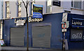
Vacant shop, Belfast (12)
A vacant electrical goods shop at the corner of Upper Queen Street (foreground) and Wellington Street. It has a notice saying that the occupant have moved to suburban premises. Some might remember it as “Shemelds”. See also Image
Image: © Albert Bridge
Taken: 15 Apr 2012
0.01 miles
8
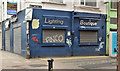
Former "Shemelds", Belfast
I took this to illustrate the shared description of “closed shops, Belfast” http://www.geograph.org.uk/snippet/6346. When I got home I discovered that I’d already photographed it before Image in April 2012. I also noticed that the Wellington Street side still has a surviving “control zone” sign – see Image See also Image
Image: © Albert Bridge
Taken: 27 Jan 2013
0.01 miles
9
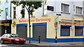
Indoor garden shop, Belfast (June 2014)
See Image (April 2012) and Image (January 2013). A long-vacant shop, at the corner of Upper Queen Street (foreground) and Wellington Street, now occupied. This photograph appears as a matter of geographical and historical record only. I have no connection with the business.
Image: © Albert Bridge
Taken: 22 Jun 2014
0.01 miles
10
Eagle Star House, Belfast (June 2019)
Not much visible behind the usual scaffolding and sheeting. Wellington Street is in the middle.
Image: © Albert Bridge
Taken: 9 Jun 2019
0.01 miles