IMAGES TAKEN NEAR TO
King Street, BELFAST, BT1 6BF
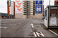
Introduction
This page details the photographs taken nearby to King Street, BT1 6BF by members of the Geograph project.
The Geograph project started in 2005 with the aim of publishing, organising and preserving representative images for every square kilometre of Great Britain, Ireland and the Isle of Man.

There are currently over 7.5m images from over14,400 individuals and you can help contribute to the project by visiting https://www.geograph.org.uk
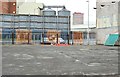
Image Map
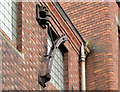
Images are licensed for reuse under creativecommons.org/licenses/by-sa/2.0
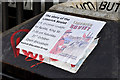
Notes
- Clicking on the map will re-center to the selected point.
- The higher the marker number, the further away the image location is from the centre of the postcode.
Image Listing (2110 Images Found)
Images are licensed for reuse under creativecommons.org/licenses/by-sa/2.0
Image
Details
Distance
1
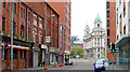
King Street, Belfast (2)
See Image King Street looking towards College Square East and College Avenue.
Image: © Albert Bridge
Taken: 17 Apr 2011
0.01 miles
2
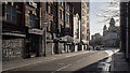
King Street, Belfast
A quiet King Street, every shop here was closed during the lockdown.
See also Image from 2011.
Image: © Rossographer
Taken: 14 Jan 2021
0.01 miles
3

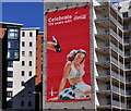
flybe poster, Belfast (July 2016)
A flybe poster, at College Avenue, advertising services from Belfast City Airport. For the record the company closed its Newcastle service this month but added a fifth daily flight to the Leeds/Bradford route.
Image: © Albert Bridge
Taken: 17 Jul 2016
0.01 miles
4
Ceramic tiles, King Street, Belfast (March 2017)
Ceramic tiles outside an arts workshop at 48 King Street.
Image: © Albert Bridge
Taken: 26 Mar 2017
0.01 miles
5
Coca-Cola 125th anniversary poster, Belfast (2)
See Image Another in the series. This one overlooks the car park at College Street.
Image: © Albert Bridge
Taken: 1 May 2011
0.02 miles
6
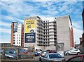
College Avenue development site, Belfast - May 2015(3)
The site, from College Court, looking towards College Avenue with Divis Tower http://www.geograph.org.uk/search.php?i=56080151 at upper right.
Image: © Albert Bridge
Taken: 31 May 2015
0.02 miles
7
Old hoist, Belfast
A surprising survival. This old hoist (only noticed it last week) is attached to the building at middle left in Image The building might (only might) once have been the Belfast Corporation Gas workshops or Spence Bros, wholesale cabinet makers and upholsterers – both of which would have been likely to use such a device.
Image: © Albert Bridge
Taken: 17 Feb 2013
0.02 miles
8
"Limerick Soviet" poster, Belfast (October 2015)
A small poster, applied to a litter bin at College Avenue, recalling the period when the scarlet banner was raised high over Limerick Image The soviet is explained in https://en.wikipedia.org/wiki/Limerick_Soviet and http://www.workersrepublic.org/Pages/Ireland/Revolution/limericksoviet.html.
Image: © Albert Bridge
Taken: 25 Oct 2015
0.02 miles
9
College Street development site, Belfast (2)
See Image More than two years later the site remains undeveloped and is used as a car park. Continue to Image (January 2013).
Image: © Albert Bridge
Taken: 25 Apr 2010
0.02 miles
10
Hotel Ibis and private student residential hall alongside the B126
The image was taken from College Street.
Image: © Eric Jones
Taken: 30 Jun 2015
0.02 miles