IMAGES TAKEN NEAR TO
Leathem Square, East Link Road, BELFAST, BT16 2QL
Introduction
This page details the photographs taken nearby to Leathem Square, East Link Road, BT16 2QL by members of the Geograph project.
The Geograph project started in 2005 with the aim of publishing, organising and preserving representative images for every square kilometre of Great Britain, Ireland and the Isle of Man.

There are currently over 7.5m images from over14,400 individuals and you can help contribute to the project by visiting https://www.geograph.org.uk
Image Map
Images are licensed for reuse under creativecommons.org/licenses/by-sa/2.0
Notes
- Clicking on the map will re-center to the selected point.
- The higher the marker number, the further away the image location is from the centre of the postcode.
Image Listing (93 Images Found)
Images are licensed for reuse under creativecommons.org/licenses/by-sa/2.0
Image
Details
Distance
1
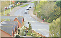
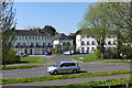
Moatview Park, Dundonald
Moatview Park (right), a development of suburban houses, as it rises away from the East Link Road.
Image: © Albert Bridge
Taken: 29 Jan 2014
0.05 miles
2
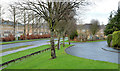
The East Link Road, Dundonald (October 2014)
The East Link Road connects the Upper Newtownards Road to the Old Dundonald Road avoiding the busy corner, with the Comber Road, at “The Elk”. Its construction also opened up a large area for suburban housing development. This view is from the moat as the road crosses the Comber Road (middle bottom).
Image: © Albert Bridge
Taken: 25 Oct 2014
0.07 miles
3
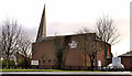
Dundonald Elim church (1)
A church, to a striking design, at the corner of the Comber Road and the East Link Road (foreground). Built (I think) in the late 1990’s, with a spire which might have been inspired by The Skylon. Image shows the view from the Comber Road.
Image: © Albert Bridge
Taken: 25 Nov 2011
0.09 miles
4
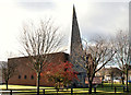
Dundonald Elim church (2)
See Image The church and spire seen from the Comber Road.
Image: © Albert Bridge
Taken: 23 Jan 2010
0.09 miles
5
Comber Greenway
Apartments on the East Link Road.
Image: © Robert Ashby
Taken: 22 Apr 2015
0.09 miles
6
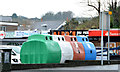
Recycling bins, Dundonald
Recycling bins in a car park on the Cumberland Road.
Image: © Albert Bridge
Taken: 29 Jan 2014
0.11 miles
7
Vacant site, Comber Road, Dundonald
Part of a vacant site between Grand Prix Park Image and the Elim church Image Continue to Image and Image
Image: © Albert Bridge
Taken: 29 Jan 2014
0.11 miles
8

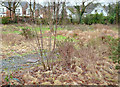
Cotoneaster berries, Dundonald (October 2015)
Cotoneaster berries in the landscaping at the Comber Road end of the East Link Road.
Image: © Albert Bridge
Taken: 21 Oct 2015
0.11 miles
9
Shared pedestrian and cycle route, Dundonald (August 2015)
It’s now becoming common, around the greater Belfast area, for what was once the pedestrians-only footpath to be signposted for use by bicycles. This example is on the Comber Road, approaching the East Link Road.
Image: © Albert Bridge
Taken: 13 Aug 2015
0.11 miles
10
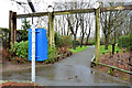
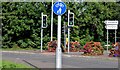
Park entrance, Dundonald
A doggy bin, at one of the entrances to Moat Park, on the Comber Road.
Image: © Albert Bridge
Taken: 29 Jan 2014
0.11 miles