IMAGES TAKEN NEAR TO
Bailey Manor, BELFAST, BT16 2NZ
Introduction
This page details the photographs taken nearby to Bailey Manor, BT16 2NZ by members of the Geograph project.
The Geograph project started in 2005 with the aim of publishing, organising and preserving representative images for every square kilometre of Great Britain, Ireland and the Isle of Man.

There are currently over 7.5m images from over14,400 individuals and you can help contribute to the project by visiting https://www.geograph.org.uk
Image Map
Images are licensed for reuse under creativecommons.org/licenses/by-sa/2.0
Notes
- Clicking on the map will re-center to the selected point.
- The higher the marker number, the further away the image location is from the centre of the postcode.
Image Listing (112 Images Found)
Images are licensed for reuse under creativecommons.org/licenses/by-sa/2.0
Image
Details
Distance
1
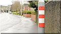
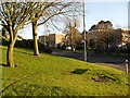
Reflective lamppost strip, Dundonald
A lamppost, with a reflective orange and white strip, at Robb’s Road near Church View (middle) – possibly an aid for drivers turning left into the street during darkness.
Image: © Albert Bridge
Taken: 6 Mar 2014
0.05 miles
2
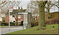
Drumadoon bus stop, Ballybeen, Dundonald
A Metro stop and shelter, at Drumadoon Drive, in the Ballybeen estate.
Image: © Albert Bridge
Taken: 6 Mar 2014
0.07 miles
3
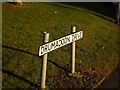
Sign, Drumadoon Drive, Ballybeen
At the junction with Robbs Road.
Image: © Dean Molyneaux
Taken: 12 Feb 2010
0.07 miles
4
Ardnoe Avenue, Dundonald
Social housing bungalows at Ardnoe Avenue, approaching the tree-lined Church Road.
Image: © Albert Bridge
Taken: 6 Mar 2014
0.08 miles
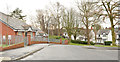
5
Drumadoon Drive, Ballybeen
The main entrance from Robbs Road into the Ballybeen Estate.
Image: © Dean Molyneaux
Taken: 12 Feb 2010
0.08 miles
6
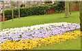
Spring flowerbed, Dundonald
A display of crocuses/croci on Robb’s Road, near the corner of Drumadoon Drive.
Image: © Albert Bridge
Taken: 6 Mar 2014
0.08 miles
7
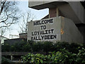
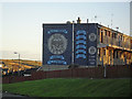
"Welcome to Loyalist Ballybeen"
The ever welcoming wall inscription on Drumadoon Drive.
Image: © Dean Molyneaux
Taken: 12 Feb 2010
0.09 miles
8
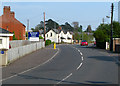
Church Road, Dundonald
Road in Dundonald.
Image: © Rossographer
Taken: 6 May 2008
0.09 miles
9
Loyalist mural, Morven Park, Ballybeen
A mural of the Red Hand Commando (RHC) Youth 'C' Company - which was based in the estate. The RHC was effectively a branch of loyalist paramilitary group the Ulster Volunteer Force - both of which were outlawed in 1973. The RHC were responsible for 12 civilian deaths and decommissioned their weapons in June 2009.
"Lamh Dearg Abú" is in fact an Irish Gaelic expression meaning "up the Red Hand [of Ulster]".
Image: © Dean Molyneaux
Taken: 12 Feb 2010
0.12 miles
10
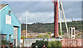
Ballybeen social apartments site, Dundonald - October 2014(3)
Work is continuing on the foundations. This helical auger is at the Robb’s Road end of the site.
Image: © Albert Bridge
Taken: 25 Oct 2014
0.14 miles