IMAGES TAKEN NEAR TO
Craignish Crescent, BELFAST, BT16 2NP
Introduction
This page details the photographs taken nearby to Craignish Crescent, BT16 2NP by members of the Geograph project.
The Geograph project started in 2005 with the aim of publishing, organising and preserving representative images for every square kilometre of Great Britain, Ireland and the Isle of Man.

There are currently over 7.5m images from over14,400 individuals and you can help contribute to the project by visiting https://www.geograph.org.uk
Image Map
Images are licensed for reuse under creativecommons.org/licenses/by-sa/2.0
Notes
- Clicking on the map will re-center to the selected point.
- The higher the marker number, the further away the image location is from the centre of the postcode.
Image Listing (98 Images Found)
Images are licensed for reuse under creativecommons.org/licenses/by-sa/2.0
Image
Details
Distance
1
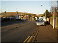
Robbs Road, Dundonald
Named after the Robb family which occupied Ballybeen House (now under a housing estate). It links the Upper Newtownards Road with the Church Road.
Image: © Dean Molyneaux
Taken: 12 Feb 2010
0.07 miles
2
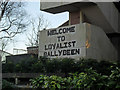
"Welcome to Loyalist Ballybeen"
The ever welcoming wall inscription on Drumadoon Drive.
Image: © Dean Molyneaux
Taken: 12 Feb 2010
0.07 miles
3
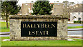
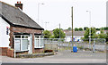
"Ballybeen estate" sign, Dundonald
A “welcome” sign, at Davarr Avenue/Craignish Crescent, close to the entrance to the Ballybeen estate
Image: © Albert Bridge
Taken: 6 Mar 2014
0.08 miles
4
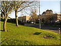
Drumadoon Drive, Ballybeen
The main entrance from Robbs Road into the Ballybeen Estate.
Image: © Dean Molyneaux
Taken: 12 Feb 2010
0.08 miles
5
No 1037 Upper Newtownards Road, Dundonald (July 2014)
A vacant bungalow, at the corner of Robb’s Road (foreground), now with a “sold” sign. The agent’s brochure described it as “The property is in need of remodelling and modernisation and therefore could be utilised to exploit its extremely valuable location with constant passing traffic and pedestrians. The property has commercial approval already granted for a business”. This photograph appears as a matter of geographical and historical record only. I have no connection with any of the parties involved in the sale. It is beside this site http://www.geograph.org.uk/snippet/11048 (mainly hidden).
Image: © Albert Bridge
Taken: 18 Jul 2014
0.08 miles
6
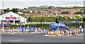
Junction improvements, Dunlady Road, Dundonald - October 2014(3)
Improvements underway, at the Upper Newtownards Road/Dunlady Road junction, to facilitate access to the proposed Dunlady Road EWAY park and ride car park. This view is from the outward side of Robb’s Road.
Image: © Albert Bridge
Taken: 11 Oct 2014
0.08 miles
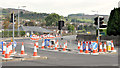
7
Junction improvements, Dunlady Road, Dundonald - October 2014(2)
Improvements underway, at the Upper Newtownards Road/Dunlady Road junction, to facilitate access to the proposed Dunlady Road EWAY park and ride car park. This view is from Robb’s Road. The Dunlady Road, as well as being an area of suburban housing, is part of the direct road from Bangor to Dundonald.
Image: © Albert Bridge
Taken: 11 Oct 2014
0.08 miles
8
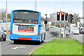
New traffic lights, Dundonald (December 2014)
The inward right-turn lane now has new traffic lights, incorporating a right-turn filter, to improve access to the Dunlady Road park and ride car park (also used by Ulsterbus services to/from Newtownards).
Image: © Albert Bridge
Taken: 1 Dec 2014
0.08 miles
9
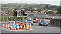
Junction improvements, Dunlady Road, Dundonald - October 2014(1)
Improvements underway, at the Upper Newtownards Road/Dunlady Road junction, to facilitate access to the proposed Dunlady Road EWAY park and ride car park. This view is from the inward side of Robb’s Road.
Image: © Albert Bridge
Taken: 11 Oct 2014
0.08 miles
10
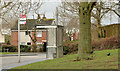
Drumadoon bus stop, Ballybeen, Dundonald
A Metro stop and shelter, at Drumadoon Drive, in the Ballybeen estate.
Image: © Albert Bridge
Taken: 6 Mar 2014
0.08 miles