IMAGES TAKEN NEAR TO
Church Road, BELFAST, BT16 2LN
Introduction
This page details the photographs taken nearby to Church Road, BT16 2LN by members of the Geograph project.
The Geograph project started in 2005 with the aim of publishing, organising and preserving representative images for every square kilometre of Great Britain, Ireland and the Isle of Man.

There are currently over 7.5m images from over14,400 individuals and you can help contribute to the project by visiting https://www.geograph.org.uk
Image Map
Images are licensed for reuse under creativecommons.org/licenses/by-sa/2.0
Notes
- Clicking on the map will re-center to the selected point.
- The higher the marker number, the further away the image location is from the centre of the postcode.
Image Listing (176 Images Found)
Images are licensed for reuse under creativecommons.org/licenses/by-sa/2.0
Image
Details
Distance
1
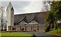
St Elizabeth's (Church of Ireland), Dundonald (2)
See Image (November 2011). The northern side of the church seen from Church Green. Continue to Image
Image: © Albert Bridge
Taken: 29 Oct 2012
0.06 miles
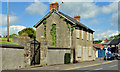
2
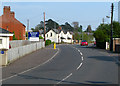
Church Road, Dundonald
Road in Dundonald.
Image: © Rossographer
Taken: 6 May 2008
0.06 miles
3
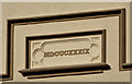
Dundonald Presbyterian church (2)
See Image The datestone on the southern (Church Green) side.
Image: © Albert Bridge
Taken: 29 Oct 2012
0.07 miles
4
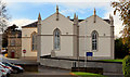
Dundonald Presbyterian church (1)
The original church was built, in what was then the country, in 1839. It was enlarged (as shown) in 1858/9 by James Entwhistle. This is the eastern (Church Road) side, now surrounded by suburban development. The small stone building (left) is the former national school of 1844. Image shows the datestone.
Image: © Albert Bridge
Taken: 29 Oct 2012
0.07 miles
5
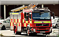
Fire appliance, Dundonald (May 2014)
In the Asda car park – not on a call.
Image: © Albert Bridge
Taken: 21 May 2014
0.08 miles
6
Derelict buildings, Dundonald - May 2014(1)
Two long-vacant former houses at the Upper Newtownards Road end of the Church Road. Image shows a chimney and its pots.
Image: © Albert Bridge
Taken: 21 May 2014
0.08 miles
7
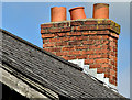
Derelict buildings, Dundonald - May 2014(2)
The disused chimneys and pots on the former house on the right in Image
Image: © Albert Bridge
Taken: 21 May 2014
0.08 miles
8
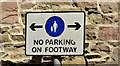
"No parking on footway" sign, Dundonald
An unusual sign, at Church Green, and the first of its type that I’ve seen. The footway, here, is similar to a long zebra crossing but parallel to the road and without a kerb - see Image The building on the left in Image is in the background.
Image: © Albert Bridge
Taken: 21 May 2014
0.08 miles
9
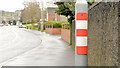
Reflective lamppost strip, Dundonald
A lamppost, with a reflective orange and white strip, at Robb’s Road near Church View (middle) – possibly an aid for drivers turning left into the street during darkness.
Image: © Albert Bridge
Taken: 6 Mar 2014
0.08 miles
10
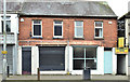
Vacant shops, Dundonald (December 2014)
Two vacant shops on the southern side of the Upper Newtownards Road – between ASDA and the Church Road.
Image: © Albert Bridge
Taken: 1 Dec 2014
0.09 miles