IMAGES TAKEN NEAR TO
Normandy Court, BELFAST, BT16 2LA

Introduction

This page details the photographs taken nearby to Normandy Court, BT16 2LA by members of the Geograph project.

The Geograph project started in 2005 with the aim of publishing, organising and preserving representative images for every square kilometre of Great Britain, Ireland and the Isle of Man.

There are currently over 7.5m images from over14,400 individuals and you can help contribute to the project by visiting https://www.geograph.org.uk

Image Map


Images are licensed for reuse under creativecommons.org/licenses/by-sa/2.0
Notes
  • Clicking on the map will re-center to the selected point.
  • The higher the marker number, the further away the image location is from the centre of the postcode.

Image Listing (160 Images Found)

Images are licensed for reuse under creativecommons.org/licenses/by-sa/2.0
  • ...
Image
Details
Distance
1
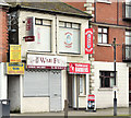
Turkish barber, Dundonald (December 2014)
See Image (August 2013). A Turkish barber on the southern side of the Upper Newtownards Road. The apartments (right) were built on the site of the old “Cherryhill Inn”.
Image: © Albert Bridge Taken: 1 Dec 2014
0.01 miles
2
Vacant shops, Dundonald (December 2014)
Two vacant shops on the southern side of the Upper Newtownards Road – between ASDA and the Church Road.
Image: © Albert Bridge Taken: 1 Dec 2014
0.01 miles
3
Vacant shops, Dundonald (2)
Vacant shops at the corner of the Upper Newtownards Road and the Church Road. This block Image is on the other (inward) side of the Church Road.
Image: © Albert Bridge Taken: 29 Oct 2012
0.02 miles
4
Vacant shops, Dundonald (1-2)
See Image The Church Road frontage of the same block.
Image: © Albert Bridge Taken: 29 Oct 2012
0.02 miles
5
Derelict buildings, Dundonald - May 2014(1)
Two long-vacant former houses at the Upper Newtownards Road end of the Church Road. Image shows a chimney and its pots.
Image: © Albert Bridge Taken: 21 May 2014
0.03 miles
6
Derelict buildings, Dundonald - May 2014(2)
The disused chimneys and pots on the former house on the right in Image
Image: © Albert Bridge Taken: 21 May 2014
0.03 miles
7
The Upper Newtownards Road (EWAY), Dundonald - June 2014(4)
See Image The view from the Church Road.
Image: © Albert Bridge Taken: 28 Jun 2014
0.03 miles
8
Nos 742-748 Upper Newtownards Road, Dundonald (October 2014)
Four vacant shops, at the corner of the Ballyregan Road (left), offered for sale. The agents’ brochure includes the following description “Ideal opportunity for owner occupier / investor”. This photograph appears as a matter of geographical and historical record only. I have no connection with any of the parties involved in the sale.
Image: © Albert Bridge Taken: 11 Oct 2014
0.03 miles
9
The Upper Newtownards Road (EWAY), Dundonald - June 2014(3)
The present arrangements (looking inwards) at the Church Road (left)/Upper Newtownards Road/Ballyregan Road crossroads where there are no existing bus-priority measures. Two points strike me here. The first is that the lanes might be narrower than other parts of the road. The second is that the inward inside lane is often used for short-stay parking. The photograph was taken during a short break in the traffic along what is usually a busy stretch. Image shows the view from the Church Road.
Image: © Albert Bridge Taken: 28 Jun 2014
0.03 miles
10
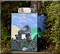
Air-quality monitoring station, Dundonald
An air-quality monitoring station, embellished by a painting of a dolmen, on the Upper Newtownards Road, opposite the ASDA exit.
Image: © Albert Bridge Taken: 29 Oct 2012
0.04 miles
  • ...