IMAGES TAKEN NEAR TO
Comber Road, BELFAST, BT16 2BT
Introduction
This page details the photographs taken nearby to Comber Road, BT16 2BT by members of the Geograph project.
The Geograph project started in 2005 with the aim of publishing, organising and preserving representative images for every square kilometre of Great Britain, Ireland and the Isle of Man.

There are currently over 7.5m images from over14,400 individuals and you can help contribute to the project by visiting https://www.geograph.org.uk
Image Map
Images are licensed for reuse under creativecommons.org/licenses/by-sa/2.0
Notes
- Clicking on the map will re-center to the selected point.
- The higher the marker number, the further away the image location is from the centre of the postcode.
Image Listing (82 Images Found)
Images are licensed for reuse under creativecommons.org/licenses/by-sa/2.0
Image
Details
Distance
1
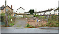
Vacant site, Dundonald
A cleared and vacant site at the corner of the Comber Road (foregroind) and Mawhinney Park.
Image: © Albert Bridge
Taken: 22 Nov 2012
0.03 miles
2
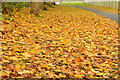
Autumn leaves, Dundonald - October 2015(2)
Autumn leaves between the Comber Road and the Moat Park playing fields. Image shows a similar view in November 2013.
Image: © Albert Bridge
Taken: 21 Oct 2015
0.06 miles
3
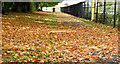
Path, Dundonald
Part of a path, in Moat Park, between the Comber Road and the playing fields Image (right).
Image: © Albert Bridge
Taken: 25 Nov 2011
0.07 miles
4
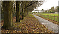
Autumn leaves, Dundonald
Until this week the trees had retained their autumn leaves but high winds, over the last three days, seem to have brought most down. This is beside the playing fields on the Comber Road. Image shows a similar view, at the same place, on 25 November 2011.
Image: © Albert Bridge
Taken: 20 Nov 2013
0.07 miles
5
Comber Greenway
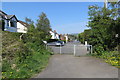
Access point at Grand Prix Park leading to the Comber Road. Near Dundonald.
Image: © Robert Ashby
Taken: 22 Apr 2015
0.08 miles
6
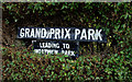
Grand Prix Park sign, Dundonald
Street on the Comber Road, Dundonald, named to commemorate the Ards TT motor race, held over the (public road) course between Dundonald/Newtownards (via Bradshaw’s Brae)/Comber/Dundonald from 1928 to 1936.
Image: © Albert Bridge
Taken: 23 Jan 2010
0.08 miles
7
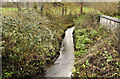
Stream, Dundonald
A stream (not named on the 1:12,000 map) flowing under the Comber Road, into the Enler River Image, a short distance to the south east. Continue to Image Image shows it at a higher level.
Image: © Albert Bridge
Taken: 25 Nov 2011
0.08 miles
8
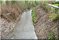
Stream, Dundonald - January 2014
See Image (November 2011). The same stream, seen from here Image, showing the effects of recent rain.
Image: © Albert Bridge
Taken: 29 Jan 2014
0.08 miles
9
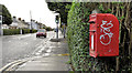
Letter box, Dundonald
Post-mounted EIIR letter box, on the Comber Road, at the corner of Grand Prix Park Image
Image: © Albert Bridge
Taken: 25 Nov 2011
0.09 miles
10
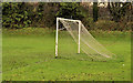
Playing fields, Dundonald (2)
Goalposts, at the south eastern end of the playing fields, in Moat Park, close to the Comber Road Image
Image: © Albert Bridge
Taken: 25 Nov 2011
0.09 miles