IMAGES TAKEN NEAR TO
Dunlady Manor, BELFAST, BT16 1YS
Introduction
This page details the photographs taken nearby to Dunlady Manor, BT16 1YS by members of the Geograph project.
The Geograph project started in 2005 with the aim of publishing, organising and preserving representative images for every square kilometre of Great Britain, Ireland and the Isle of Man.

There are currently over 7.5m images from over14,400 individuals and you can help contribute to the project by visiting https://www.geograph.org.uk
Image Map
Images are licensed for reuse under creativecommons.org/licenses/by-sa/2.0
Notes
- Clicking on the map will re-center to the selected point.
- The higher the marker number, the further away the image location is from the centre of the postcode.
Image Listing (3 Images Found)
Images are licensed for reuse under creativecommons.org/licenses/by-sa/2.0
Image
Details
Distance
1

Letter box and drop box, Dundonald (1)
Post-mounted EIIR letter box (BT16 309) and drop box, on the Dunlady Road Image at Dunlady Manor. See also Image
Image: © Albert Bridge
Taken: 21 Apr 2012
0.11 miles
2

Letter box and drop box, Dundonald (2)
See Image The box is now showing the new times for the last collection.
Image: © Albert Bridge
Taken: 21 Apr 2012
0.11 miles
3
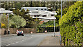
The Dunlady Road, Dundonald (2)
The suburban part of the Dunlady Road, looking downhill towards here Image and the Upper Newtownards Road, as it climbs towards Craigantlet crossroads Image
Image: © Albert Bridge
Taken: 21 Apr 2012
0.12 miles