IMAGES TAKEN NEAR TO
Comber Road, BELFAST, BT16 1XB
Introduction
This page details the photographs taken nearby to Comber Road, BT16 1XB by members of the Geograph project.
The Geograph project started in 2005 with the aim of publishing, organising and preserving representative images for every square kilometre of Great Britain, Ireland and the Isle of Man.

There are currently over 7.5m images from over14,400 individuals and you can help contribute to the project by visiting https://www.geograph.org.uk
Image Map
Images are licensed for reuse under creativecommons.org/licenses/by-sa/2.0
Notes
- Clicking on the map will re-center to the selected point.
- The higher the marker number, the further away the image location is from the centre of the postcode.
Image Listing (34 Images Found)
Images are licensed for reuse under creativecommons.org/licenses/by-sa/2.0
Image
Details
Distance
1
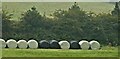
Bales near Dundonald (October 2015)
Silage bales, behind a hedge on the Comber road seen, through a light mist, from the Comber Greenway.
Image: © Albert Bridge
Taken: 2 Oct 2015
0.02 miles
2
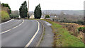
The Comber Road near Dundonald
Another twisting section of the Comber Road, on the Dundonald side of Image This hedge Image is on the right. See also Image
Image: © Albert Bridge
Taken: 18 Jan 2012
0.02 miles
3
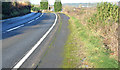
The Comber Road near Dundonald (January 2015)
See Image (January 2012). Three years later, the same stretch of road, in sunshine.
Image: © Albert Bridge
Taken: 8 Jan 2015
0.05 miles
4
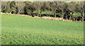
The Enler River near Dundonald (January 2015)
A straight stretch of the Enler, downstream from here Image, marked by the line of trees, seen from this part of the Comber Road Image
Image: © Albert Bridge
Taken: 8 Jan 2015
0.06 miles
5
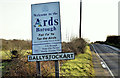
Ballystockart name and "welcome" signs, Dundonald/Comber (January 2015)
Name and “welcome” signs at Ballystockart, on the Comber Road. Reorganisation of local government boundaries comes into effect on 1 April 2015. The North Down Borough Council website records “At a Special Council meeting of North Down and Ards District Council on Monday 15 December, Councillors voted in favour of changing the Council’s name to “East Coast Borough Council”. . . . . In the New Year the Council will formally apply for Borough status and will submit an application to the DoE [Department of the Environment] to change the name to East Coast Borough Council with effect from 1 April 2015; until then the Council will be known as North Down and Ards District Council”.
Image: © Albert Bridge
Taken: 8 Jan 2015
0.07 miles
6
Cut hedge, Comber/Dundonald
Horizontally-cut hedge, beside the Belfast Road Image, near Ballystockart.
Image: © Albert Bridge
Taken: 18 Jan 2012
0.08 miles
7
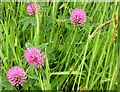
Clover, Comber Greenway - May 2014(1)
Part of a profuse display of clover, along the Greenway, on the Comber side of this bridge Image See also Image
Image: © Albert Bridge
Taken: 28 May 2014
0.08 miles
8
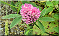
Clover, Comber Greenway - May 2014(2)
See Image A single flower, apart from the main growth, which shows the leaves very clearly.
Image: © Albert Bridge
Taken: 28 May 2014
0.08 miles
9
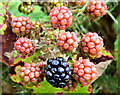
Blackberries, Comber Greenway - August 2014(1)
Blackberries were growing in abundance along the greenway. This was one of the very few which was properly ripe and black.
Image: © Albert Bridge
Taken: 4 Aug 2014
0.09 miles
10
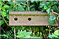
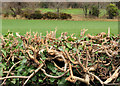
Old rail, Dundonald/Comber (August 2014)
64 years after the Belfast Comber/Donaghadee/Newcastle line closed, this old bullhead rail is still part of a fence along the Comber Greenway.
Image: © Albert Bridge
Taken: 4 Aug 2014
0.10 miles