IMAGES TAKEN NEAR TO
Peartree Hill, BELFAST, BT16 1XA
Introduction
This page details the photographs taken nearby to Peartree Hill, BT16 1XA by members of the Geograph project.
The Geograph project started in 2005 with the aim of publishing, organising and preserving representative images for every square kilometre of Great Britain, Ireland and the Isle of Man.

There are currently over 7.5m images from over14,400 individuals and you can help contribute to the project by visiting https://www.geograph.org.uk
Image Map
Images are licensed for reuse under creativecommons.org/licenses/by-sa/2.0
Notes
- Clicking on the map will re-center to the selected point.
- The higher the marker number, the further away the image location is from the centre of the postcode.
Image Listing (14 Images Found)
Images are licensed for reuse under creativecommons.org/licenses/by-sa/2.0
Image
Details
Distance
1
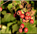
Haws, Dundonald
Some surviving haws beside the Comber Road, close to Peartree Hill.
Image: © Albert Bridge
Taken: 9 Dec 2013
0.16 miles
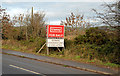
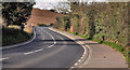
2
Development site, Dundonald (2)
See Image The Comber Road with the site on the right. This photograph appears as a matter of record only. I have no connection with any of the parties involved in the sale. Continue to Image
Image: © Albert Bridge
Taken: 9 Dec 2013
0.16 miles
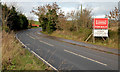
3
Development site, Dundonald (1)
A development site for sale beside the Comber Road, on the Dundonald side of the Billy Neill School of Soccer Excellence. I cannot find any information on the agent’s website. This photograph appears as a matter of record only. I have no connection with any of the parties involved in the sale. Image shows the site in its setting beside the road.
Image: © Albert Bridge
Taken: 9 Dec 2013
0.17 miles
4
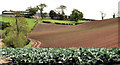
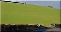
Drumlin near Dundonald
Cabbages, growing in a field beside the New Line Image, with the gentle slope of a small drumlin in the background.
Image: © Albert Bridge
Taken: 28 Jul 2011
0.18 miles
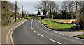
5
The Belfast Road, Dundonald
Another twisting part of the Belfast Road, looking towards Dundonald, to the west of Image
Image: © Albert Bridge
Taken: 17 Mar 2012
0.19 miles
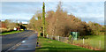
6
The Blefast Road, Comber/Dundonald (4)
Another twisting part of the Belfast Road, looking towards Comber. The minor road (bottom right) is Peartree Hill – a private (I think) lane.
Image: © Albert Bridge
Taken: 17 Mar 2012
0.20 miles
7
Development site, Dundonald (3)
See Image The view along the Comber Road towards Dundonald. The site is behind the trees (middle/right). This photograph appears as a matter of record only. I have no connection with any of the parties involved in the sale.
Image: © Albert Bridge
Taken: 9 Dec 2013
0.21 miles
8
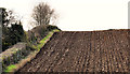
Ploughed field, Dundonald
Part of a ploughed drumlin field, on the western side of the Belfast Road, close to Image
Image: © Albert Bridge
Taken: 17 Mar 2012
0.21 miles
9
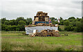
Bonfire, Dundonald
Traditional loyalist '11th night' bonfire https://en.wikipedia.org/wiki/Eleventh_Night located off Miller's Drive on the edge of Ballybeen, Dundonald.
Image: © Rossographer
Taken: 10 Jul 2022
0.21 miles
10
Drumlin, Dundonald (2)
A large drumlin field, on the western side of the Comber Road, approaching Dundonald - possibly the most prominent natural feature of the road from Comber. Unfortunately old 25” maps for the area are not available on-line but it does look as if hedges have been removed at some past time.
Image: © Albert Bridge
Taken: 9 Dec 2013
0.21 miles