IMAGES TAKEN NEAR TO
Stoney Road, BELFAST, BT16 1UP
Introduction
This page details the photographs taken nearby to Stoney Road, BT16 1UP by members of the Geograph project.
The Geograph project started in 2005 with the aim of publishing, organising and preserving representative images for every square kilometre of Great Britain, Ireland and the Isle of Man.

There are currently over 7.5m images from over14,400 individuals and you can help contribute to the project by visiting https://www.geograph.org.uk
Image Map
Images are licensed for reuse under creativecommons.org/licenses/by-sa/2.0
Notes
- Clicking on the map will re-center to the selected point.
- The higher the marker number, the further away the image location is from the centre of the postcode.
Image Listing (4 Images Found)
Images are licensed for reuse under creativecommons.org/licenses/by-sa/2.0
Image
Details
Distance
1
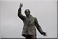
Parliament Buildings, Stormont, Belfast (2)
See Image This is the statue of Sir Edward Carson http://multitext.ucc.ie/d/Edward_Carson.
Image: © Albert Bridge
Taken: 24 May 2007
0.14 miles
2
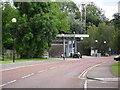
Filling Station, Stormont Estate
A filling station for government vehicles on the Stormont Estate - opposite Castle Buildings.
Image: © Dean Molyneaux
Taken: 9 Jul 2009
0.15 miles
3
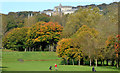
Knock Golf Club, Belfast (2)
See Image Part of the course seen from the Upper Newtownards Road. Parliament Buildings and Stormont Castle are at middle top.
Image: © Albert Bridge
Taken: 1 Nov 2013
0.18 miles
4
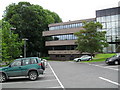
Castle Buildings, Stormont Estate
Castle Buildings is a large government building on the Stormont Estate - housing the Office of First Minister and Deputy First Minister (OFMDFM) and the Department of Health, Social Services and Public Safety (DHSSPSNI).
Image: © Dean Molyneaux
Taken: 9 Jul 2009
0.19 miles