IMAGES TAKEN NEAR TO
Dunleady Park, BELFAST, BT16 1JX
Introduction
This page details the photographs taken nearby to Dunleady Park, BT16 1JX by members of the Geograph project.
The Geograph project started in 2005 with the aim of publishing, organising and preserving representative images for every square kilometre of Great Britain, Ireland and the Isle of Man.

There are currently over 7.5m images from over14,400 individuals and you can help contribute to the project by visiting https://www.geograph.org.uk
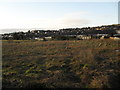
Image Map
Images are licensed for reuse under creativecommons.org/licenses/by-sa/2.0
Notes
- Clicking on the map will re-center to the selected point.
- The higher the marker number, the further away the image location is from the centre of the postcode.
Image Listing (70 Images Found)
Images are licensed for reuse under creativecommons.org/licenses/by-sa/2.0
Image
Details
Distance
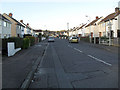
1

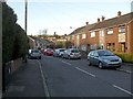
Canberra Gardens, Dundonald
A short cul-de-sac of bungalows off Canberra Park (Image).
Image: © Dean Molyneaux
Taken: 12 Feb 2010
0.04 miles
2
Dunleady Park, Dundonald
Off Canberra Park. The townland name is normally spelt 'Dunlady' - from the Irish Gaelic 'Dún Léide' (Léide's Fort).
Image: © Dean Molyneaux
Taken: 12 Feb 2010
0.06 miles
3
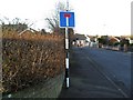
No-through road sign, Dundonald
At the bottom of Canberra Gardens at the junction with Canberra Park.
Note the pre-Worboys pole with modern sign.
Image: © Dean Molyneaux
Taken: 12 Feb 2010
0.06 miles
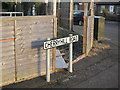
4
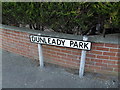
Sign, Dunleady Park, Dundonald
At the junction with Canberra Park.
The townland name is typically spelt 'Dunlady', from the Irish Gaelic 'Dún Léide' (Léide's Fort).
Image: © Dean Molyneaux
Taken: 12 Feb 2010
0.07 miles
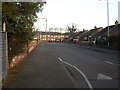
5
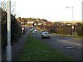
Dunlady Road, Dundonald
Leading north from the eastern end of Dundonald village towards Craiganlet and Bangor.
Image: © Dean Molyneaux
Taken: 12 Feb 2010
0.09 miles
6
Waste ground, Dundonald
Off the Dunlady Road - behind Canberra Park.
Image: © Dean Molyneaux
Taken: 12 Feb 2010
0.10 miles
7
Cherryhill Road, Dundonald
The northern portion of Cherryhill Road leading to newer housing in the Grangewood development.
Image: © Dean Molyneaux
Taken: 12 Feb 2010
0.11 miles
8
Canberra Park, Dundonald
Leads from the Cherryhill Road to the Dunlady Road.
Image: © Dean Molyneaux
Taken: 12 Feb 2010
0.11 miles
9

Proposed park and ride car park, Dundonald - October 2014(2)
The exit road under construction (opposite Tor Bank School).
Image: © Albert Bridge
Taken: 11 Oct 2014
0.12 miles
10
Street name sign, Cherryhill Road, Dundonald
A standard urban Castlereagh Borough Council street name sign located where Canberra Park meets the Cherryhill Road.
Image: © Dean Molyneaux
Taken: 12 Feb 2010
0.12 miles