IMAGES TAKEN NEAR TO
Cherryhill Road, BELFAST, BT16 1JH
Introduction
This page details the photographs taken nearby to Cherryhill Road, BT16 1JH by members of the Geograph project.
The Geograph project started in 2005 with the aim of publishing, organising and preserving representative images for every square kilometre of Great Britain, Ireland and the Isle of Man.

There are currently over 7.5m images from over14,400 individuals and you can help contribute to the project by visiting https://www.geograph.org.uk
Image Map
Images are licensed for reuse under creativecommons.org/licenses/by-sa/2.0
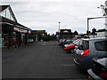
Notes
- Clicking on the map will re-center to the selected point.
- The higher the marker number, the further away the image location is from the centre of the postcode.
Image Listing (159 Images Found)
Images are licensed for reuse under creativecommons.org/licenses/by-sa/2.0
Image
Details
Distance
1
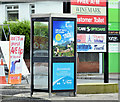
Telephone box, Dundonald (December 2014)
A KX100 telephone box at the Cherryhill Eurospar Image
Image: © Albert Bridge
Taken: 1 Dec 2014
0.03 miles
2
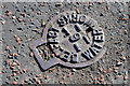
Belfast Waterworks access cover, Dundonald
A Belfast Waterworks access cover (possibly over a stop valve), with the number “6”, on the Upper Newtownards Road, at the corner of the Cherryhill Road.
Image: © Albert Bridge
Taken: 11 Oct 2014
0.03 miles
3
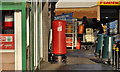
Pillar box, Dundonald
EIIR pillar box at the post office on the Upper Newtownards Road.
Image: © Albert Bridge
Taken: 25 Nov 2011
0.04 miles
4
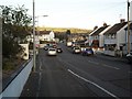
Cherryhill Road, Dundonald
The lower - and busiest - portion of this road.
Image: © Dean Molyneaux
Taken: 12 Feb 2010
0.04 miles
5
Shops, Cherryhill, Dundonald
A retail block at Cherryhill on the Upper Newtownards Road in Dundonald.
Image: © Dean Molyneaux
Taken: 17 Jul 2009
0.04 miles
6
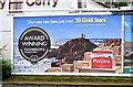
"Punjana" Giant's Causeway poster, Dundonald (November 2014)
See Image (December 2012). A poster advertising “Punjana” tea, using the Giant’s Causeway as a background, beside the Upper Newtownards Road, Dundonald.
Image: © Albert Bridge
Taken: 28 Nov 2014
0.04 miles
7
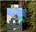
Air-quality monitoring station, Dundonald
An air-quality monitoring station, embellished by a painting of a dolmen, on the Upper Newtownards Road, opposite the ASDA exit.
Image: © Albert Bridge
Taken: 29 Oct 2012
0.05 miles
8
Small retail park off the Upper Newtownards Road, Dundonald
Image: © Eric Jones
Taken: 21 May 2012
0.05 miles
9
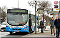
Bradshaw's Brae bus, Dundonald
An Ulsterbus Wrightbus-bodied Scania (754 TCZ 1754) calling at the Cherry Hill (Asda) stop, on the Upper Newtownards Road, with the 11.30 Newtownards – Belfast Laganside Buscentre. Most Newtownards-Belfast services run via the dual carriageway Image This is one of the few to use the old road over Bradshaw’s Brae Image
Image: © Albert Bridge
Taken: 6 Mar 2014
0.05 miles
10
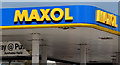
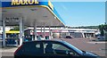
Petrol station canopy, Dundonald
The eye-catching blue and yellow corporate identity at the Cherryhill Service Station on the Upper Newtownards Road. The colours make Maxol stations easy to spot from a distance. More of them are now offering the choice of paying in the shop or (as here) at the pump. Last seen in Image (May 2012).
Image: © Albert Bridge
Taken: 18 Apr 2013
0.05 miles