IMAGES TAKEN NEAR TO
Donegall Square East, BELFAST, BT1 5HD
Introduction
This page details the photographs taken nearby to Donegall Square East, BT1 5HD by members of the Geograph project.
The Geograph project started in 2005 with the aim of publishing, organising and preserving representative images for every square kilometre of Great Britain, Ireland and the Isle of Man.

There are currently over 7.5m images from over14,400 individuals and you can help contribute to the project by visiting https://www.geograph.org.uk
Image Map
Images are licensed for reuse under creativecommons.org/licenses/by-sa/2.0
Notes
- Clicking on the map will re-center to the selected point.
- The higher the marker number, the further away the image location is from the centre of the postcode.
Image Listing (3116 Images Found)
Images are licensed for reuse under creativecommons.org/licenses/by-sa/2.0
Image
Details
Distance
1
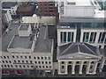
Imperial House / Ulster Bank, Belfast
An aerial view from the Belfast Wheel.
Image: © Kenneth Allen
Taken: 30 Mar 2009
0.00 miles
2
Metro minibus, Belfast
A Metro Optare Solo, at Donegall Square East (shown as the Calhame Road on the Google map), awaits its next turn to the Royal Victoria Hospital Image
Image: © Albert Bridge
Taken: 15 Oct 2009
0.00 miles
3
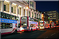
Buses, Belfast
'Metro' buses queued on Donegall Square East to serve the evening rush hour in Belfast.
Image: © Rossographer
Taken: 17 Dec 2009
0.00 miles
4
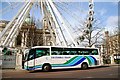
Titanic tour, Belfast
An Ulsterbus coach visiting the Titanic memorial Image as part of the “Titanic Designed and Built in Belfast” exhibition now running at W5 in the Odyssey Image Continue to Image
Image: © Albert Bridge
Taken: 22 Mar 2009
0.01 miles
5
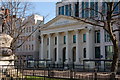
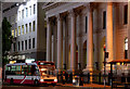
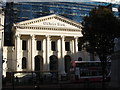
Former Methodist church, Belfast
The Methodist church Image in Donegall Square East, Belfast was built in 1847, destroyed by fire in 1849 and rebuilt in 1850. It fell victim to the bombing campaign in central Belfast when its congregation forsook it for suburban churches. Later unused but listed the façade has now been incorporated into the recently built head office of the Ulster Bank. (It sits astride two squares).
Image: © Albert Bridge
Taken: 1 Apr 2007
0.01 miles
6
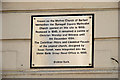
Methodist church plaque, Belfast
Plaque on the Ulster Bank Image in Donegall Square East (Calhame Road on the Google map), recording the building’s original role as Donegall Square East Methodist church Image
Image: © Albert Bridge
Taken: 11 Apr 2010
0.01 miles
7

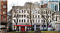
Donegall Square East, Belfast
The view along Donegall Square East (incorrectly shown as the Calhame Road on the Google map) towards Adelaide Street. The buses for most of south Belfast depart from here.
Image: © Albert Bridge
Taken: 5 Dec 2008
0.01 miles
8
Imperial House, Belfast
An Art Deco office building, in Donegall Square East, completed in 1935 to a design by Kendrick Edwards. Listed as HB26/50/190, it was greatly improved by an internal restoration and an external cleaning. In case anyone has forgotten, it was once occupied by ICI (Imperial Chemical Industries Limited) which also had a factory at Carrickfergus - now closed and known as Kilroot Business Park. Image shows an elevated view in November 2007.
Image: © Albert Bridge
Taken: 1 Jan 2012
0.01 miles
9
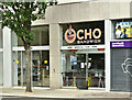
"Ocho", Belfast (June 2018)
A sandwich shop on the ground floor of Imperial House Image, 8 Donegall Square East. “Your local Coffee and Sandwich Bar with Fresh Sandwiches and Salads made especially for you along with a selection of tea, coffee and scones”. I have no connection with the business and cannot take orders.
Image: © Albert Bridge
Taken: 17 Jun 2018
0.01 miles
10
The iconic facade of the Ulster Bank in Donegall Square East
The facade, a listed structure, is a recycled feature. Previously it was the facade of a Methodist Church which stood on the same site and abandoned after it was bombed in WWII. It now forms a grand entrance to the Belfast City Offices of the Ulster Bank - the blue glass and steel building behind.
Image: © Eric Jones
Taken: 3 Nov 2014
0.01 miles