IMAGES TAKEN NEAR TO
BELFAST, BT1 5AE
Introduction
This page details the photographs taken nearby to BT1 5AE by members of the Geograph project.
The Geograph project started in 2005 with the aim of publishing, organising and preserving representative images for every square kilometre of Great Britain, Ireland and the Isle of Man.

There are currently over 7.5m images from over14,400 individuals and you can help contribute to the project by visiting https://www.geograph.org.uk
Image Map
Images are licensed for reuse under creativecommons.org/licenses/by-sa/2.0
Notes
- Clicking on the map will re-center to the selected point.
- The higher the marker number, the further away the image location is from the centre of the postcode.
Image Listing (3333 Images Found)
Images are licensed for reuse under creativecommons.org/licenses/by-sa/2.0
Image
Details
Distance
1
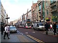
Donegall Place (after the fire), Belfast - September 2018(2)
3.25 pm, close to Fountain Lane, looking towards the City Hall - very quiet. By contrast other streets were very busy. A Council statement dated 21 September 2018 shows that fourteen businesses are currently closed.
Image: © Albert Bridge
Taken: 24 Sep 2018
0.00 miles
2
Primark, Donegall Place, Belfast - February 2019(1)
The former “New Look” now being converted to a Primark to replace the fire-damaged Bank Buildings shop.
Image: © Albert Bridge
Taken: 3 Feb 2019
0.00 miles
3
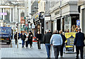
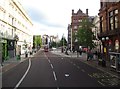
Metro Buses in Donegall Place
The Metro operates along a dozen corridor route within the boundaries of the city.
http://en.wikipedia.org/wiki/Metro_(Belfast)
Image: © Eric Jones
Taken: 13 Dec 2012
0.01 miles
6
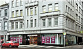
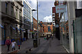
"New Look", Fountain House, Belfast - January 2019(1)
Following a corporate insolvency, announced in early 2018, the New Look shop at Fountain House, Donegall Place is due to close on 15 January 2019.
It stretches back to Fountain Street. Media reports suggest that Primark will be the new occupant following the Bank Buildings fire.
Image: © Albert Bridge
Taken: 6 Jan 2019
0.01 miles
7
New Primark, Belfast (May 2019)
The replacement for the fire-damaged Bank Buildings, now open in the former “New Look”, Donegall Place.
Image: © Albert Bridge
Taken: 6 May 2019
0.01 miles
8
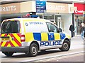
PSNI City Centre Beat mobile in Donegall Place
The City Centre Beat is approximately 5 square miles and is bounded by the River Lagan, Ormeau Avenue, Millfield and Dock Street. It also includes the old Gasworks site.
Image: © Eric Jones
Taken: 28 Jul 2015
0.01 miles
9
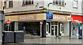
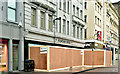
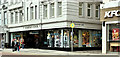
No 28 Donegall Place, Belfast (February 2016)
See Image The former “Barratts”, at the corner of Castle Lane, remains vacant.
Image: © Albert Bridge
Taken: 21 Feb 2016
0.01 miles
10
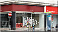
No 28 Donegall Place, Belfast (April 2016)
The “Barratts” signs have been removed to show a sign from a tenant before “Clinton Cards”. The flowers are in memory of a homeless woman who died, in the shop doorway, last month – see http://www.bbc.co.uk/news/uk-northern-ireland-35860690. The doorway of the shop on the right is in similar use.
Image: © Albert Bridge
Taken: 3 Apr 2016
0.01 miles