IMAGES TAKEN NEAR TO
Shore Crescent, BELFAST, BT15 4JT
Introduction
This page details the photographs taken nearby to Shore Crescent, BT15 4JT by members of the Geograph project.
The Geograph project started in 2005 with the aim of publishing, organising and preserving representative images for every square kilometre of Great Britain, Ireland and the Isle of Man.

There are currently over 7.5m images from over14,400 individuals and you can help contribute to the project by visiting https://www.geograph.org.uk
Image Map
Images are licensed for reuse under creativecommons.org/licenses/by-sa/2.0
Notes
- Clicking on the map will re-center to the selected point.
- The higher the marker number, the further away the image location is from the centre of the postcode.
Image Listing (39 Images Found)
Images are licensed for reuse under creativecommons.org/licenses/by-sa/2.0
Image
Details
Distance
1
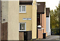
Gables, Belfast
Brightly-coloured south-facing gables at Shore Crescent.
Image: © Albert Bridge
Taken: 11 Nov 2013
0.01 miles
2
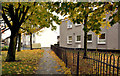
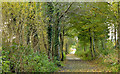
Autumn trees and leaves, Fortwilliam, Belfast
Autumn trees and leaves, along a footpath, close to the southern entrance to Shore Crescent.
Image: © Albert Bridge
Taken: 11 Nov 2013
0.06 miles
3
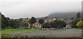
Houses off Shore Road
A mist covered Cave Hill forms the background.
Image: © Eric Jones
Taken: 23 Sep 2013
0.06 miles
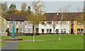
4
Shore Crescent, Belfast (1)
Despite the name the estate is laid out on strict right-angled geometric lines – in this case a square. The Horizon Building Image is in the background, on the Shore Road. The boarded-up block on the right is a case where appearances can be deceptive. It’s relatively new but still unlet. The agents’ website shows it as completely modern inside.
Image: © Albert Bridge
Taken: 11 Nov 2013
0.08 miles
5
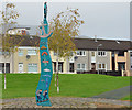
"Sailortown" feature, Shore Crescent, Belfast
A feature, the square, inscribed “Sailortown”. When Sailortown http://www.geograph.org.uk/search.php?i=45062275 was flattened in the 1960/70’s to make way for the M2 some of its residents moved here.
Image: © Albert Bridge
Taken: 11 Nov 2013
0.08 miles
6
Shore Crescent, Belfast (2)
Despite the name the estate is laid out on strict right-angled geometric lines – in this case a square. The view, approximately north west, across the square. The feature (left) is inscribed “Sailortown”. When Sailortown http://www.geograph.org.uk/search.php?i=45062275 was flattened in the 1960/70’s to make way for the M2 some of its residents moved here.
Image: © Albert Bridge
Taken: 11 Nov 2013
0.10 miles
7
The Horizon Building, Belfast (2)
See Image The view from the south east.
Image: © Albert Bridge
Taken: 11 Nov 2013
0.11 miles
8
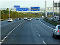
Sign Gantry over the M2 near Greencastle
The M2 is the main road north from Belfast, carrying traffic from the city to the north and north-west of the province.
Image: © David Dixon
Taken: 29 Sep 2017
0.11 miles
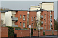
9
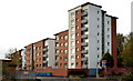
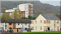
The Horizon Building, Belfast (1)
Five blocks of apartments, at 670-678 Shore Road, which rise progressively in height from south to north. This view is from the north east. Image shows the view from the south east.
Image: © Albert Bridge
Taken: 11 Nov 2013
0.12 miles
10
Park path, Belfast
Trees along the path on the eastern side of the Loughside Park. Not obvious but the railway and M2 motorway can be heard but not seen on the left. This photograph appears as a matter of record only and is not part of any campaign for or against commercial development proposals.
Image: © Albert Bridge
Taken: 11 Nov 2013
0.12 miles