IMAGES TAKEN NEAR TO
Grays Lane, BELFAST, BT15 4HT
Introduction
This page details the photographs taken nearby to Grays Lane, BT15 4HT by members of the Geograph project.
The Geograph project started in 2005 with the aim of publishing, organising and preserving representative images for every square kilometre of Great Britain, Ireland and the Isle of Man.

There are currently over 7.5m images from over14,400 individuals and you can help contribute to the project by visiting https://www.geograph.org.uk
Image Map
Images are licensed for reuse under creativecommons.org/licenses/by-sa/2.0
Notes
- Clicking on the map will re-center to the selected point.
- The higher the marker number, the further away the image location is from the centre of the postcode.
Image Listing (23 Images Found)
Images are licensed for reuse under creativecommons.org/licenses/by-sa/2.0
Image
Details
Distance
1
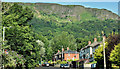
Gray's Lane and the Cave Hill, Belfast (July 2019)
The partly-wooded slopes of the Cave Hill, overlooking Gray’s Lane, on a glorious sunny summer day. The street is named after Captain George Gray, a Victorian gentleman who owned a nearby house called “Graymount".
Image: © Albert Bridge
Taken: 14 Jul 2019
0.02 miles
2
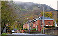
Gray's Lane, Belfast (1)
This view is towards the Antrim Road from opposite Graymount Drive.
Image: © Albert Bridge
Taken: 11 Nov 2013
0.02 miles
3
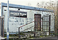
Derelict buildings, Shore Road/Gray's Lane, Belfast - January 2017(4)
The former Arthur Ward’s bar on the Gray’s Lane side.
Image: © Albert Bridge
Taken: 29 Jan 2017
0.07 miles
4
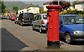
Pillar box, Belfast
EIIR pillar box (BT37 591) at the Shore Road end of Gray’s Lane. Gray’s Lane is within the Belfast City Council area and has a postcode of BT15.
Image: © Albert Bridge
Taken: 25 May 2012
0.08 miles
5
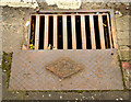
Millfield Foundry rodding access cover, Greencastle, Belfast (1)
See Image A Millfield Foundry rodding access cover at the Shore Road end of Gray’s Lane. Image shows the maker’s name and date of casting.
Image: © Albert Bridge
Taken: 22 Feb 2013
0.08 miles
6
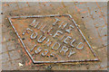
Millfield Foundry rodding access cover, Greencastle, Belfast (2)
See Image The inscription showing the maker’s name and the date of casting (1935).
Image: © Albert Bridge
Taken: 22 Feb 2013
0.08 miles
7
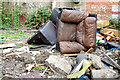
Fly tipping, Shore Road, Belfast (September 2014)
Domestic furniture dumped on this vacant site Image at the corner of Gray’s Lane and the Shore Road (hidden right).
Image: © Albert Bridge
Taken: 19 Sep 2014
0.08 miles
8
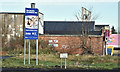
Vacant site, 792 Shore Road, Belfast (January 2017)
The vacant site – now with a sign announcing the proposed construction of new social housing.
Image: © Albert Bridge
Taken: 29 Jan 2017
0.09 miles
9
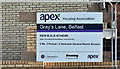
No 792 Shore Road, Belfast - July 2019(2)
Housing association sign on the Gray’s Lane side.
Image: © Albert Bridge
Taken: 14 Jul 2019
0.09 miles
10
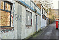
Derelict buildings, Shore Road/Gray's Lane, Belfast - January 2017(3)
The derelict former bar on the Gray’s Lane side. The next building (a bookmaker) is not included in the shared description.
Image: © Albert Bridge
Taken: 29 Jan 2017
0.09 miles