IMAGES TAKEN NEAR TO
Antrim Road, BELFAST, BT15 4EP
Introduction
This page details the photographs taken nearby to Antrim Road, BT15 4EP by members of the Geograph project.
The Geograph project started in 2005 with the aim of publishing, organising and preserving representative images for every square kilometre of Great Britain, Ireland and the Isle of Man.

There are currently over 7.5m images from over14,400 individuals and you can help contribute to the project by visiting https://www.geograph.org.uk
Image Map
Images are licensed for reuse under creativecommons.org/licenses/by-sa/2.0
Notes
- Clicking on the map will re-center to the selected point.
- The higher the marker number, the further away the image location is from the centre of the postcode.
Image Listing (16 Images Found)
Images are licensed for reuse under creativecommons.org/licenses/by-sa/2.0
Image
Details
Distance
1

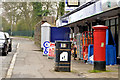
Belfast, Antrim Road
The Antrim Road is a major arterial route and area of housing and commerce that runs from inner city north Belfast to Dunadry. It forms part of the A6 road, a traffic route which links Belfast to Derry.
Image: © David Dixon
Taken: 26 May 2017
0.03 miles
2
Pillar box BT15 557, Belfast
EIIR pillar box (BT15 557) on the Antrim Road, south of Gray’s Lane.
Image: © Albert Bridge
Taken: 30 Mar 2014
0.05 miles
3

Lane
Leads from Cave Hill Country Park to Antrim Road.
Image: © Paul McIlroy
Taken: 17 May 2007
0.06 miles
4
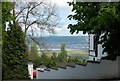
View from Antrim Road
Looking east to Holywood.
Image: © Paul McIlroy
Taken: 17 May 2007
0.06 miles
5
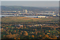
Belfast from Cave Hill
Looking over north Belfast and the harbour estate from the lower slopes of Cave Hill https://en.wikipedia.org/wiki/Cavehill .
Image: © Rossographer
Taken: 30 Oct 2016
0.07 miles
6
Gray's Lane, Belfast - September 2014(4)
The Antrim Road end of Gray’s Lane.
Image: © Albert Bridge
Taken: 19 Sep 2014
0.08 miles
7
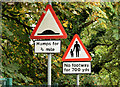
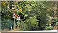
"Humps" and "no footway" signs, Belfast (September 2014)
“Humps” and “no footway” signs at the Antrim Road end of the narrow and twisting Gray’s Lane Image
Image: © Albert Bridge
Taken: 19 Sep 2014
0.08 miles
8
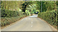
Gray's Lane, Belfast - September 2014(3)
The view, uphill, in the direction of the Antrim Road at another of the many bends. The sound of club on ball is a feature of most of the road.
Image: © Albert Bridge
Taken: 19 Sep 2014
0.09 miles
9
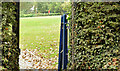
Gate, Gray's Lane, Belfast (September 2014)
The hedges, on both sides of Gray’s Lane, are punctuated by numerous gates which allow golfers to cross between the two parts of the course. This one is on the south western side, close to here Image
Image: © Albert Bridge
Taken: 19 Sep 2014
0.10 miles
10
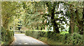
Gray's Lane, Belfast - September 2014(2)
Looking uphill, at one of the road’s many bends, in the direction of the Antrim Road. There is a slight autumn mist over the golf course adding to the rural feel of what is really a suburban road.
Image: © Albert Bridge
Taken: 19 Sep 2014
0.17 miles